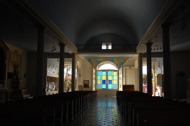
The Beautiful Fishing Cove of Tortugas, near Casma, Ancash, Peru
Tortugas is one of those places you want to share with everyone you know, while also being a little selfish and keeping its charm to yourself. With so much coastline along the Pacific ocean, there are lots of beaches to choose from when visiting Peru. Limeños flock to the beaches an hour or two south of the capital, like Punta Hermosa, Asia, and Pulpos, while foreigners often head north to the beaches of Piura and Tumbes, especially party-central, Máncora. The fishing village of Huanchaco, outside of Trujillo, is increasingly popular, especially among surfers, but what happens if you just want to relax and get away from the crowds?
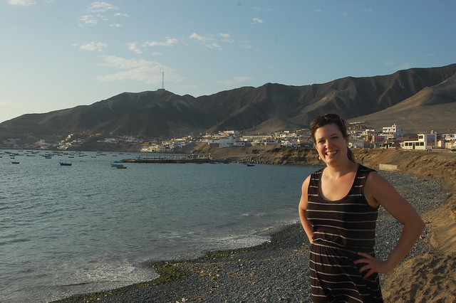
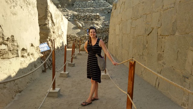
Posing in Tortugas, Ancash, Peru
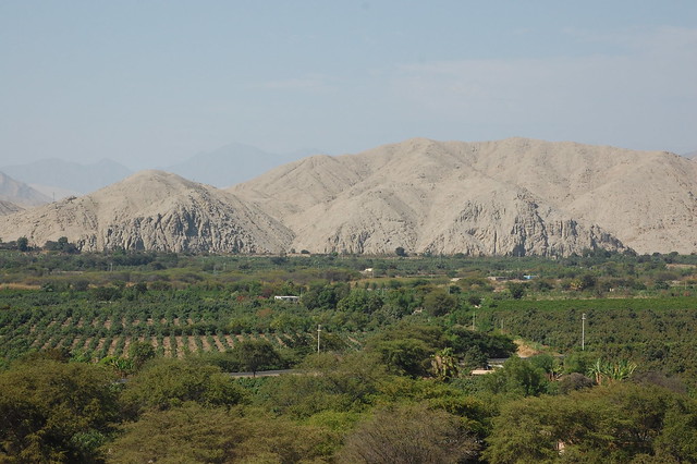
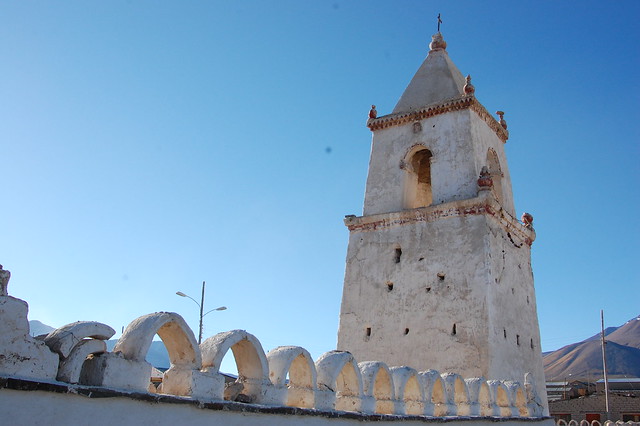
That’s where Tortugas comes in. Tortugas is a small fishing village located around a beautiful bay in the department of Ancash. Ancash has a number of notable sites; beyond Casma and the ruins of Cerro Sechín, it is also home to the major archeological site, Chavín de Huantar, the city of Huaraz, and the amazing lakes and mountains of the Cordillera Blanca. With such popular neighbors, it’s no wonder that Tortugas remains a bit of a secret.
Tortugas first came on my radar back in 2013, where I came across a couple of articles naming Tortugas one of the most beautiful beaches in Peru and basically calling it paradise. My interest was piqued.
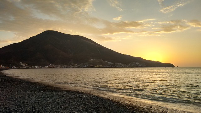
Setting Sun in Tortugas, Ancash, Peru
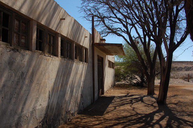
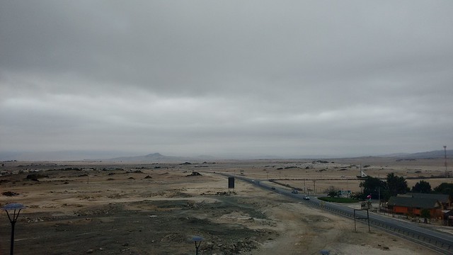
After checking out the nearby ruins of Sechín, my friend Enzo and I boarded a combi (small bus) heading to Tortugas. The combis leave regularly from a parking lot right off the main plaza, and it takes about 20 minutes to get to Tortugas. The route takes you through the barren desert lining the main roads, no water to be seen anywhere, before finally reaching the turnoff and the long paved road to Tortugas, which is located about 2-3 kilometers from the Panamerican highway.
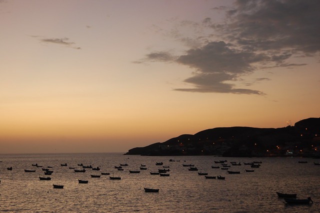
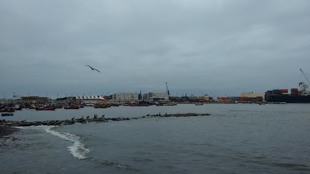
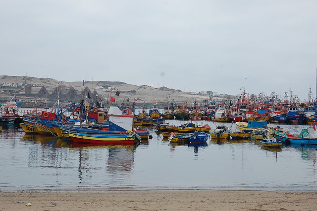
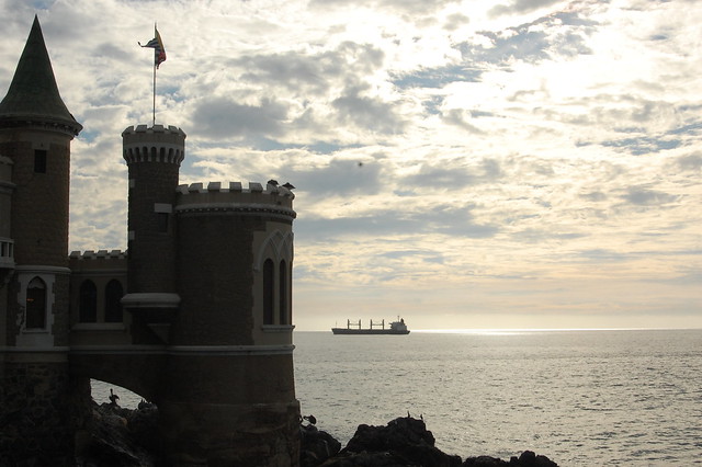
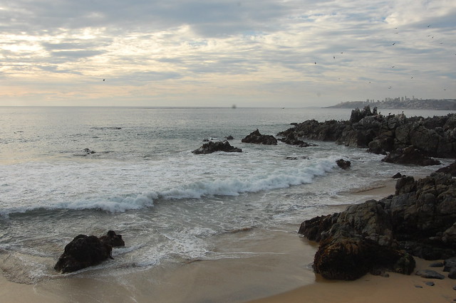
Fishing Boats at Dusk in Tortugas, Ancash, Peru
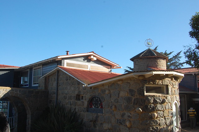
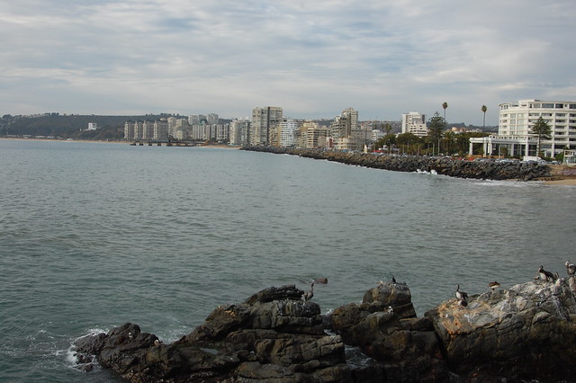
It didn’t look like much as we approached, but then the combi came to a stop at the entrance to the town, right in front of the bay. We arrived just as the late afternoon sun was illuminating the hills surrounding the bay, coating everything with a golden glow. How could you not fall in love with this little village?
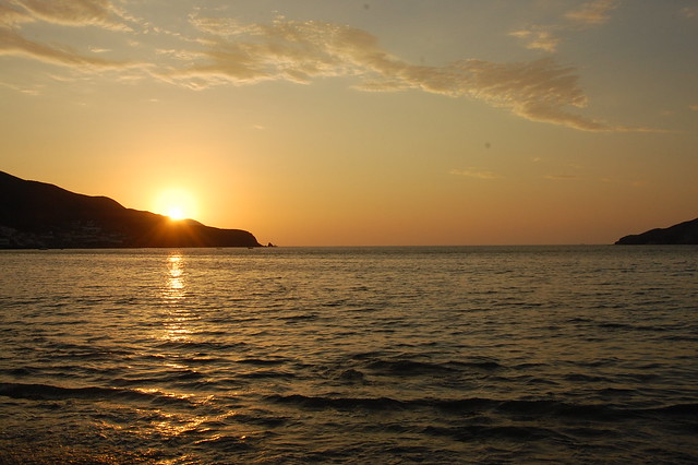
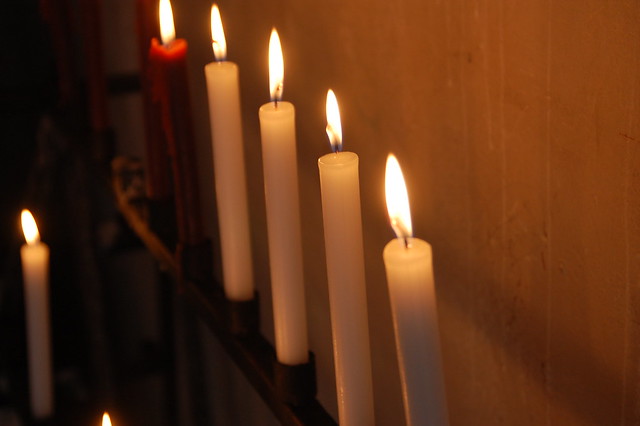
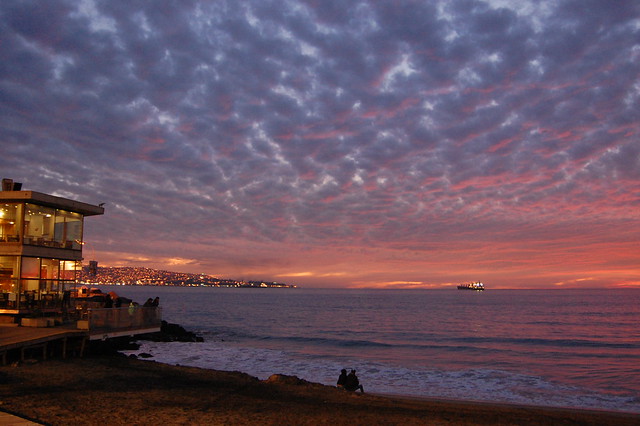
Sun Setting Over the Beautiful Bay of Tortugas, Ancash, Peru
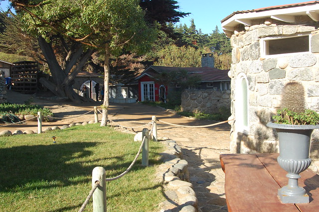
We wandered up the main road, finding a restaurant that doubled as an hostal with rooms for rent in the back. After dropping off our things, we headed back outside to catch what ended up being a gorgeous sunset.
Sunset in Tortugas, Ancash, Peru
Tortugas, which means turtles or tortoises in Spanish, received its name due to the quantity of the creature that used to swim in its waters one hundred years ago. Today, it is known for its beautiful views, relaxed environment, and plentiful ceviche. There are a number of restaurants and kiosks selling quick meals, but the town maintains its laid-back feel, catering mainly to those who have summer homes here and the occasional tourist.
Sunset in Tortugas, Ancash, Peru
There’s not much to do in Tortugas besides take it easy and enjoy the views. We walked up and down the main road after nightfall, appreciating some downtime to talk about what had been happening in our lives over the past year. With a couple of playgrounds and plenty of viewpoints to sit and listen to the water, there is enough simple entertainment to enjoy a relaxing evening.
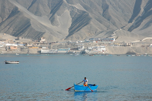
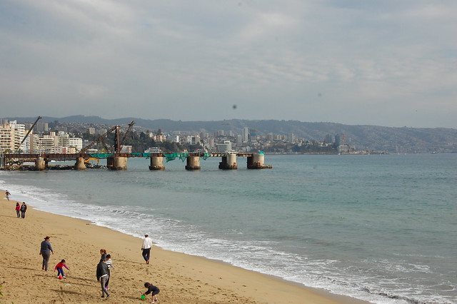
Fishing Boats in Casma, Ancash, Peru
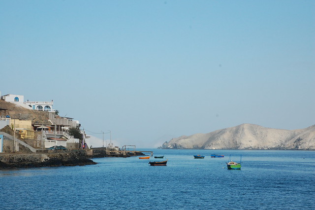
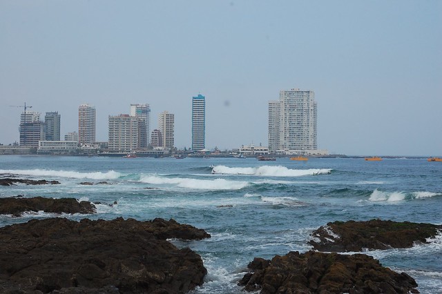
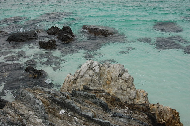
After a good night’s sleep, we woke up early to enjoy some time in the water before heading back to Casma. In the morning light, I saw the visual appeal of Tortugas: the water is incredibly clear and a shade of gorgeous shimmering blue.
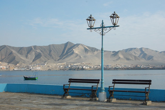
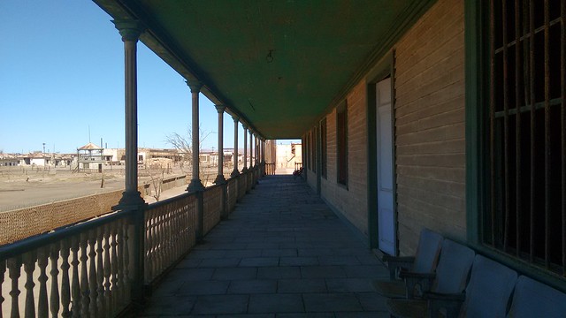
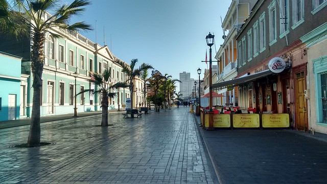
Malecón in Tortugas, Ancash, Peru
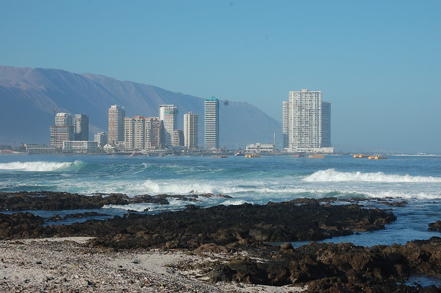
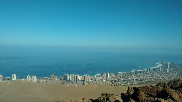
We retraced our steps of the night before, walking further away from the center of town to get a nice view of the entire bay. From this vantage point, you see just how many buildings have sprung up around the base of the mountains, but there is enough space for everyone, no high rise hotels blocking the view.
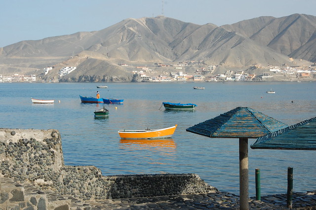
Tortugas, Ancash, Peru
The water in Tortugas is incredibly warm, making swimming super pleasant. As I waded into the water, I had one of those special moments that I still remember today, appreciating the reality of being somewhere lovely, in good company, where everything is perfectly okay. I felt lucky to have the chance to get to know Tortugas before beginning my new job later that month.
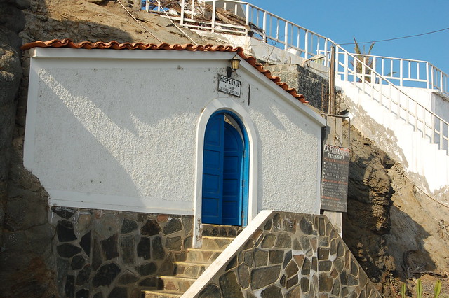
Adorable Hospedaje (Lodging) in Tortugas, Ancash, Peru
The Fishing Village of Tortugas, Ancash, Peru
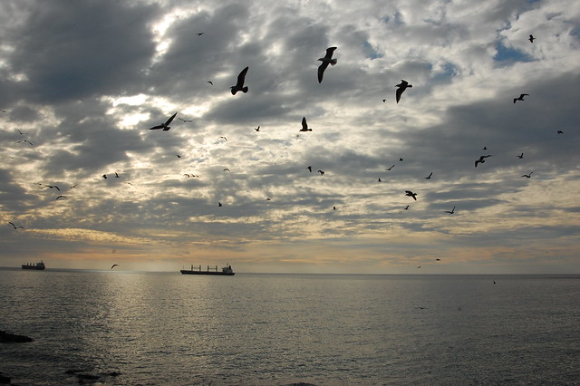
After a pleasant stroll around the perimeter of Tortugas, we headed back to the center of town to get our things and catch a bus back to Casma. It was a good thing we got up early, as we managed to see the clear blue skies illuminating the cove; the coastal clouds began to roll in as we were leaving.
Fishing Boat in Tortugas, Ancash, Peru
As you can see, Tortugas is a postcard of tranquility, a nice escape from the crowded beaches elsewhere along the coast, and well worth a visit if you are passing through Casma en route to Chimbote, Huaraz, or Trujillo. This is a place to plan to spend a couple of days relaxing, taking in the incredibly warm waters of the bay, and reading by the water or catching up with friends or family. It might be even a nice place for a do-it-yourself writing or meditation retreat, or a place to spend quiet time with your partner if you need to reconnect away from the distractions of the city.
Playground in Tortugas, Ancash, Peru
Tortugas is one of my favorite small towns in Peru and is an easy trip from Lima. While its charm comes from the fact that it is quiet and uncomplicated by the tourism industry, it deserves a visit from independent travelers looking to experience coastal Peru as locals do.
Recommendations for Tortugas, Ancash, Peru:
Tortugas is located near Casma, a small coastal city located just off the Panamerican highway. To get to Casma from Lima, you can take a bus from Plaza Norte; Erick El Rojo and 3 Estrellas are two commonly used bus companies. For other potential transportation options, please read my post on Sechín, the archeological site just outside of Casma.
Once in Casma, there are combis (small buses) and colectivos (shared taxis) which leave from a parking lot just off the Plaza de Armas in Casma, near the municipality building. Ask anyone to point you towards the buses for Tortugas. The bus cost about S/. 4 in January 2015; the current cost should be posted on the front windshield of the bus. The bus ride takes about 20 minutes and takes you along the Panamericana before turning towards Tortugas and heading the 2 kilometers towards the water.
There are several hostales and hospedajes in Tortugas, many of which are attached to restaurants. Around the new year, camping on the beach is also common; this is a low-budget destination for many Peruvian families and groups of friends.
There are several restaurants serving all kinds of fish, especially ceviche, but if you want something a little more budget friendly, there are several outdoor food stands located up in the residential area. This is also where the buses back to Casma leave from, and a good place to buy fresh fruit.
The weather in Casma is warm, and the water of the bay is incredibly pleasant. Make sure to bring your bathing suit!
When I decided to spend a couple of weeks in Lima before moving to Chile, I knew I wanted to take advantage of my completely open schedule and sneak up the coast to Casma. I had read about the ruins at Sechín in Hugh Thomson’s fascinating book, A Sacred Landscape, and was curious about the gruesome carvings depicting beheadings, sacrifices, and soldiers. I hadn’t managed to make it there in 2013 so didn’t want to miss this opportunity to get back into the travel mode. I’d also heard that the nearby beach of Tortugas is one of the most beautiful in Peru, and decided to kill two birds with one stone.
Casma is located about five hours north of Lima in the province of Ancash, but it can take some work to find a bus company that actually stops in Casma rather than continuing up the coast to Trujillo or inland to Huaraz. Alternatively, there are combis that hit the major towns on the coast and you should be able to find one that heads to Casma by stopping in one of the transit towns like Supe or Barranca. (More travel information in my recommendations, below.) The ride up the Panamericana passes the entrance to Caral, and the scenery is consistent with the northern coast; the sea to one side, sandy desert hills to the other.
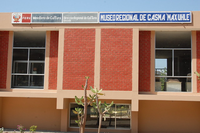
Museum at the Ruins of Sechín, Ancash, Peru
It’s worth mentioning that there are three archeological sites in the area: Cerro Sechín, which is commonly referred to as as Sechín, as well as Sechín Alto and Sechín Bajo, which are being studied but are not easily visited by casual tourists. There is also the Río Sechín, so it may help to specify “El Templo” (the Temple) or “El Museo” (the Museum) when discussing your destination.
Archeological Relics in the Museum at Sechín, Ancash, Peru
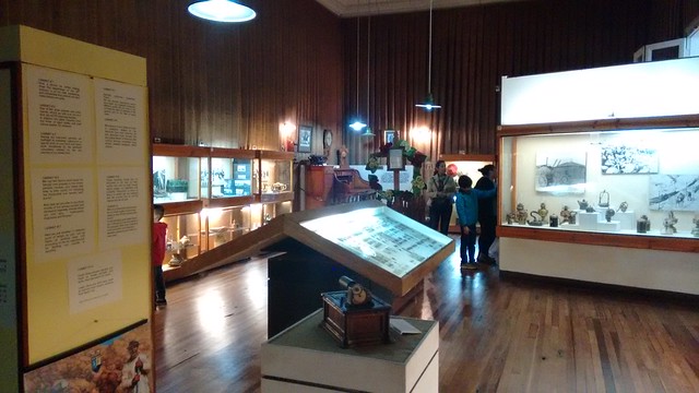
The archeological site of Cerro Sechín is located about 6 kilometers from Casma, and the easiest way to get there is to find a mototaxi willing to take you out to the site. At the site, the friendly guards directed us to the museum, where we paid our entrance fee and toured the sparse museum containing relics gathered from the major sites located in the area.
Landscape Around the Ruins of Sechín, Ancash, Peru
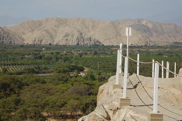
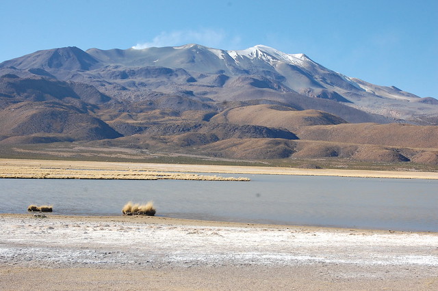
From there, we walked over to the small set of ruins, following a well constructed pathway which provides great views of the surrounding landscape. As in Trujillo and Chiclayo to the north, there are broad fields of green trees and patches of empty brown desert mountains. Taking in the scenery, I was reminded of how much I love northern Peru.
Ruins of Sechín, Ancash, Peru
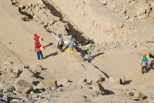
The site of Sechín itself is very small and still under investigation. My friend Enzo and I were the only ones touring the ruins in the late afternoon sun, though we could observe a number of workers going about their daily routines below.
Posing at the Viewpoint above Sechín, Ancash, Peru
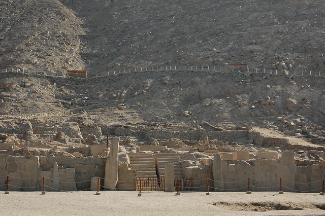
Although it’s challenging to make out to the untrained eye, archeologists have determined that the site has one main building, surrounded by stones, and filled in the center with adobe structures.
Pathway At Cerro Sechín and Its Views
The hill above the site once had other residential or administrative buildings, which have been destroyed by heavy rains over the centuries.
Workers Finishing Up for the Day at the Ruins of Sechín
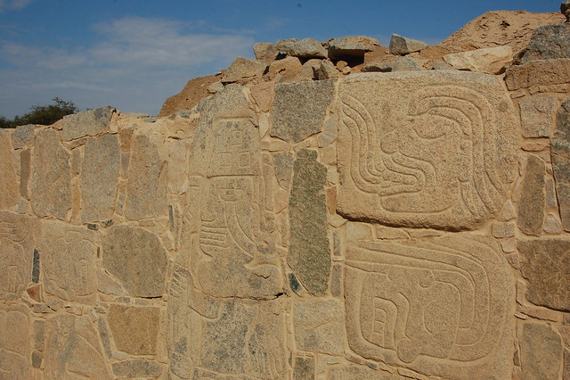
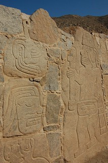
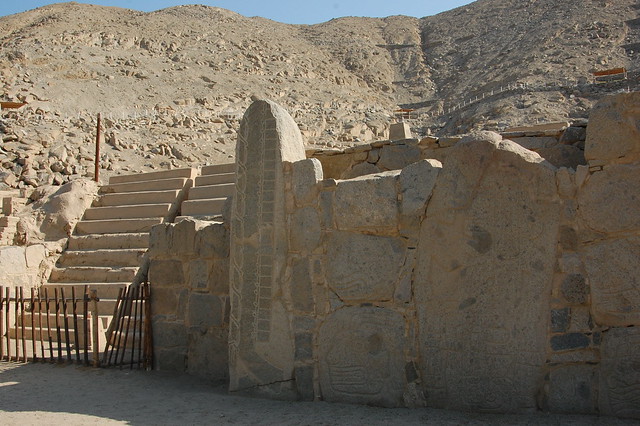
After completing our circuit around and above the ruins, we descended to get up close to the elaborate carvings depicting intriguing ancient ceremonies.
Carvings at Cerro Sechín Leading to the Entrance to the Temple
The images that line the entrance to the temple represent human figures, most likely warriors or perhaps priests, involved in what appears to be a fierce battle. None of the figures represent gods or other mythical creatures: just humans.
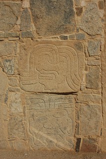
Carvings at Cerro Sechín, Ancash, Peru
While some of the figures possess their entire bodies, there are also many disembodied heads and all kinds of body parts, leading many researchers to suggest that these carvings describe human sacrifice. Other ideas are that they record violent combats experienced by the Sechín culture, or even that all these different images of various appendages could represent a medical encyclopedia.
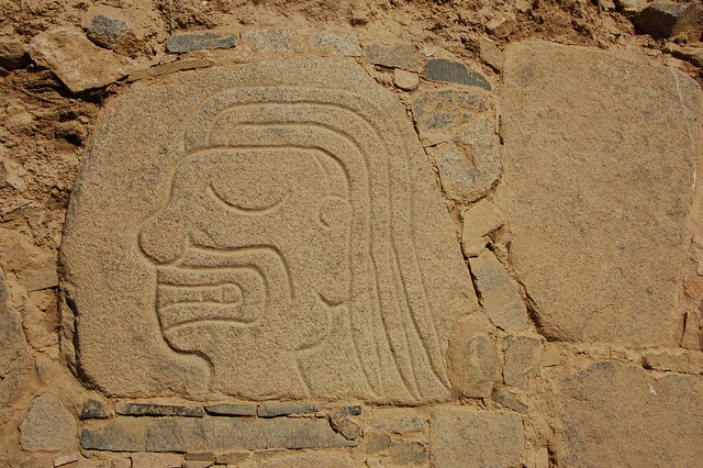
Disembodied Head Carving at the Ruins of Cerro Sechín, Ancash, Peru
Whatever the story, the figures show gritted teeth and swollen eyes, what appears to be blood or energy flowing out of their heads, grimaces and signs of suffering.
In these photos, you can see some of the body parts, some of the complete figures carrying what appears to be weapons or holy staffs, and examples of the faces both in profile and head on. There are so many images that it’s difficult to really observe all of them, especially in the brutal sun of the northern desert.
These images are located within pathways that appear to continue around the perimeter of the temples, telling stories. One big question mark for me after my visit is that these walls appear to be reconstructed.
I’m not sure if these monoliths were found standing independently, and then archeologists reinforced the structures with like-colored stones and adobe, or if the walls had crumbled. I know from my visit to Caral that reconstructing original structures is a painstaking, detail-oriented process, and I learned at Chan Chan in Trujillo that previous preservation attempts actually meant re-carving and replicating the original images, which had deteriorated from the adobe walls after years of rain and wind.
Posing at the Ruins of Cerro Sechín, Ancash, Peru
We wandered through the perimeter pathways, taking in all the different variations on what appeared to be quite a violent theme. I laugh when I see the photos of myself posing there because I appear to be enjoying my visit to what historically was likely a gruesome site.
There is a lot to take in, and I applaud the authorities for making the images accessible to visitors even as they continue to study the ruins and unearth more information about what took place here.
Entrance to the Palace at Cerro Sechín, Ancash, Peru
The visit ends in front of the entrance to the palace, which is off-limits to visitors. According to this fascinating article (in Spanish), the inside of the palace has painted adobe walls displaying images of fish, particularly carnivorous ones, as well as shamans and dead or dying human figures. These images suggest some sort of connection with worship of the sea or concern regarding rainfall in this desert climate.
Mototaxis Waiting at the Entrance to Cerro Sechín
In any case, my brief visit left me wanting more information about these ruins and the nearby sites of Sechín Alto and Sechín Bajo. (There are a couple of displays giving basic information about these archeological sites near the small parking lot where these mototaxis were waiting.) While many of the carvings have characteristics in common with the more well-known Chavín culture, represented in great detail at Chavín de Huantar (blog post forthcoming!), it has been determined that Sechín came much earlier. Visiting Sechín helped me place these ruins in my mental timeline of the pre-Incan cultures that once inhabited Peru.
Heading Back to Casma from Cerro Sechín
After finding the last mototaxi not waiting for one of the workers at Sechín, we headed back to Casma, enjoying the wind blowing in our faces as we passed through the agricultural fields along the hills.
Plaza of Casma, Ancash, Peru
Back in Casma, we took a stroll through the pleasant plaza, grabbed a quick snack, and looked for the combis that would take us to Tortugas, a fishing village known for its beautiful bay. We had finished appreciating on of Peru’s ancient cultures for the day, and it was time to relax by the water.
Recommendations for Sechín, Ancash, Peru:
To get to Casma from Lima, take a bus to Casma using the company Erick El Rojo, which leaves from the Plaza Norte bus terminal in Lima. You can get to the bus terminal using the Metropolitano, so it’s pretty straightforward. In 2015, the buses left Lima at 7:30AM, 9AM, and 11AM, but you should definitely double check the schedule. Bring snacks – there is often traffic on the highway the bus stops frequently in urban areas to pick up more passengers.
Alternatively, you can try taking a bus that is heading to Chimbote, Trujillo, or Huaraz and asking the driver to let you off at the crossroads to Casma. From there, you can take a mototaxi to Casma or to the ruins of Sechín.
Your last option would be to take a bus or combi to Supe or Barranca and then find another combi to Casma. A good place to start would be to check with are Turismo Barranca and Turismo Paramonga, which also leave from the Terminal Terrestre Plaza Norte.
To get back to Lima, you can go to the office of Erick El Rojo on the main road entering Casma. We were able to book our bus back at the last minute, as the buses come from further north and pass through the town.
The entrance fee to the ruins of Cerro Sechín cost me S/.5 in 2015, but I have seen the price listed as S/.6 in other locations.
If you get off the bus in Casma, you will need to take a mototaxi to the ruins. This should cost about S/.5. You can try asking the mototaxi to wait for you or return for you at the ruins at a set time. There are several mototaxis that wait for tourists – if it is late in the day, like it was for us, they will probably charge you S/.6.
I’m not sure if the museum offers guided tours or if there are sometime guides lingering around, but there is no signage so it may be nice to try to find someone to give you some background. I had read about Sechín in Hugh Thomson’s A Sacred Landscape so had enough background to understand what I was seeing. Having toured the larger, more popular ruins around Trujillo, I know how much a guide can help shed some light on the excavation and restoration process.
If you read Spanish, Wikipedia, Arqueotur, and Arquelogía del Perú (the most detailed and educational) provide some more information on the ruins, which helped inform my understanding a little more.
Views of the Chilean Altiplano en route to Parque Nacional Isluga, Chile
There are times when an independent traveler wants to take local buses and explore ruins or beautiful landscapes at a relaxed pace. And then there are times when taking an organized tour is the more economical and convenient option, due to massive distances or the need for an off-road vehicle. But then there are other times when your tour guide shows a passion for promoting and protecting the rich regional heritage that is often missed by tourists quickly passing through en route to somewhere more famous, when this knowledgable person serves as a gateway into the history and culture of a fascinating region. This was the case on my tour to Parque Nacional Isluga.
On my last full day in Iquique, I signed up for the Parque Nacional Isluga tour for two reasons: I was curious about the weavings from Isluga that were on display at the Museo Regional de Iquique, and I wanted to see the high altitude Andean landscape in this part of the country. I had already visited the gorgeous lagoons in Parque Nacional Lauca, near Arica, and the wonders of the Atacama Desert, near San Pedro, and I was curious how the scenery changed over here.
In the end, beyond the scenery and textiles, this tour ended up illuminating so many aspects of life in the northern desert over the past few centuries, and inspired me to keep on traveling and exploring Chile. Fair warning: this post is very long and picture-heavy, but I want to encourage other travelers to take the time to visit this area on their way through Chile!
El Gigante de Atacama
El Gigante de Atacama, near Tarapacá, Chile
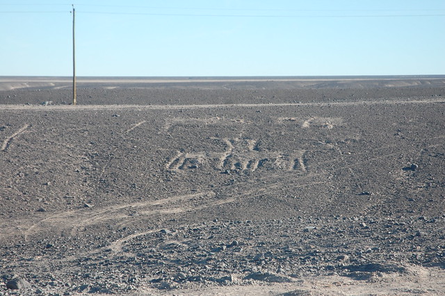
The tour left Iquique very early in the morning for one good reason: we wanted to make it to the Gigante de Atacama before the sun came up over the mountain. The Gigante de Atacama, or the Giant of the Atacama Desert, is a huge geoglyph carved into the side one of the hills found in the middle of the expanses of sand. These geoglyphs are found throughout northern Chile, and for the most part, archeologists are still studying and debating the meaning of the figures.
Sun Coming Up Directly Over the Gigante de Atacama
The Gigante de Atacama is well-known because of its massive size and its very clearly humanoid shape. As in many of the rock carvings I saw in Yerbas Buenas, near San Pedro de Atacama, the figure looks like a shaman. This shape could represent an important meeting or could be a signpost signaling a particular travel route (speculation found here). In any case, I was struck by the fact that the sun rises directly over the top of the head of the Gigante de Atacama; like many ancient Andean cultures, whoever carved this figure into the mountain was well aware of the path of the sun.
Geoglyphs near El Gigante de Atacama
It is no accident that the sun rises directly over his head; the visual impact of illumination appearing slowly and strongly above this giant figure could represent spiritual or intellectual insight. According to our guide, other geoglyphs in this same “family” also appear to have been designed in connection with the sun, coordinated with the sunset and movements of this and other celestial bodies over the course of the year. Fascinating stuff. Near the Gigante de Atacama, there are other intriguing shapes and figures, as you see above.
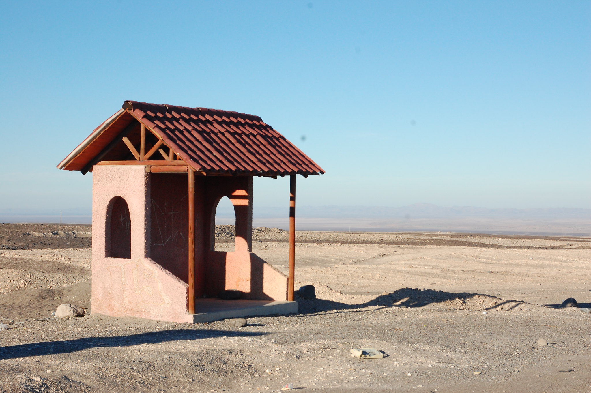
Isolated Bus Stop to Bolivia in the Desierto de Atacama, near Tarapacá, Chile
At this point in my tour, our guide was encouraged because a number of us showed serious interest in the ancient cultures of the Atacama and the speculations about the origins and reasons behind these figures. As a reward, he decided to take us somewhere not usually included on the tour.
Ruta 15, Not the Inca Trail
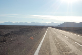
As we returned to Ruta 15, we passed a road very clearly carved into the desert, just a faded outline, but very distinct. This was the Camino del Inca, the Inca Trail, passing through the desert. Less impressive than the stonework found in the Andes, it rarely catches the attention of people passing by, but there it remains, cut through by modern roads, passed over by off-road vehicles, but still there.
Ruta 15 continues up into the high Andes all the way to the Bolivian border. I was surprised to see this isolated bus stop in the middle of the desert, but with all the mining in the area and transit to and from Bolivia, this shelter provides some shade from the sun for whoever ends up waiting.
Asterisk in the Atacama Desert
Ancient Pottery in the Atacama Desert
We parked near the bus shelter (hence the photos) and got out to walk through the desert to our special destination. As we walked through the sand, we glanced down our feet and saw shards of pottery just about everywhere, preserved by the relentless sun. This simple pottery was not painted in any way, which our guide said suggested that it was used for ceremonial purposes, and these were likely pieces that fell off the loads being carried along the way.
Asterisk in the Atacama Desert
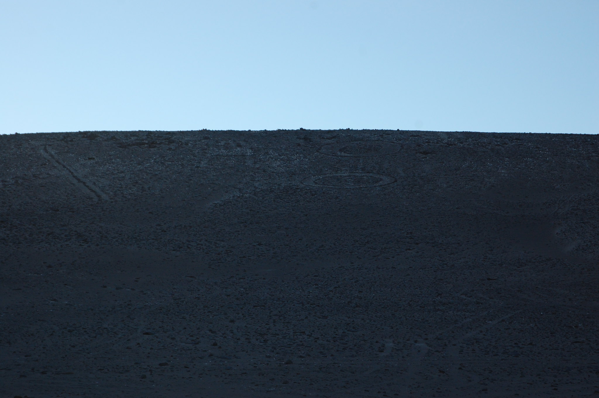
After a short walk, we arrived at this incredibly curious geoglyph: a giant asterisk carved into the desert. Like the geoglyphs and the desert section of the Inca Trail, this asterisk was created by digging into the earth and turning up the lighter layers of sand, and using the darker rocks to create a contrast visible in the desert.
Asterisk in the Atacama Desert
Similar to the Nasca Lines of Peru, this desert asterisk is more visible from above, and this is exactly how they found it. According to our guide, Google Earth led those curious about the mysteries of the Atacama to discover this intriguing shape. There is a section that was run over by an off-road motorcycle, whose rider probably had no idea he was passing through what seems to be a ceremonial site.
Textures of the Rocks of the Desert Asterisk
In this photo, you can see the textures and colors of the rocks used to mark out the desert asterisk. This is inhospitable landscape, and at some point in the past, there was a reason to mark this location or record this shape.
Asterisk in the Atacama Desert
That’s the fascinating thing about traveling through the Andes, and the reason I was so inspired by my trip. There are many things we know, but so many things we don’t know, and will probably never know. It’s just part of the mystery of the region, of our past as humans. Some people have reported seeing flying objects in the sky flashing lights in this configuration, so one theory among the curious is that this may have been a symbol indicating a landing pad. I’ll leave it up to them to debate. 🙂
Geoglyphs in the Atacama Desert
After sufficiently appreciating the asterisk, we headed back to the tour van and continued along Ruta 15. Of course, we spotted many other geoglyphs along the way. These appeared to be a little more traditional, shapes relating to animals and other figures of daily life. As you can see from the photo, unregulated offroad vehicles have damaged the desert around the geoglyphs, turning up the rocks surrounding them. It’s hard to convince people that rocks and sand are part of Chile’s national heritage and need to be protected.
Mirador Alto Pachica & Quebrada de Tarapacá
Mirador Alto Pachica, View of the Quebrada de Tarapacá
Our next stop on the climb up Ruta 15 into the high Andes was the Mirador Alto Pachica, a viewpoint that offers a broad view of the Quebrada de Tarapacá. Down below in the valley, there is more vegetation around the rivers, so farming villages still persist. (For Spanish readers, there is some interesting information about the various towns of the area here.)
Mirador Alto Pachica, View of the Quebrada de Tarapacá
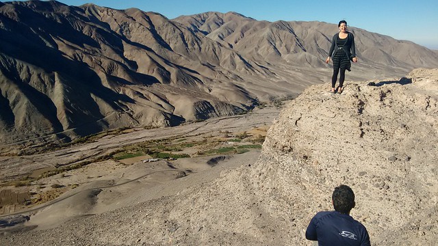
Personally, I was most fascinated by the views of Inca terracing. Ever since my trip to Peru back in 2007, I have been intrigued by how the Incas (and their predecessors) carved out ways to grow crops in seemingly impossible locations. Our guide explained that engineers have studied the way water was moved from one place to another in this valley and still don’t fully understand how the ancient system worked.
Posing above the Quebrada de Tarapacá
Of course, this kind of view requires posing for pictures. Our guide took lots of photos of us from the best vantage point, and promised to send them along. Unfortunately, this never happened, but I have this shot of me posing for the pictures taken by one of my fellow tourists.
Views of the Desert Hills in the Atacama Desert in the Tarapacá Region
We continued our climb into the higher altitude of the Andes, watching the landscape change from brown and beige to the rich reds and oranges from the mineral-rich mountains. One glance at these colors makes it unsurprising that mining is big business in the area!
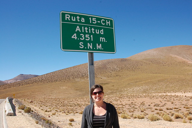
Ruta 15, Altitude 4351 Meters above sea level
Finally, we reached the highest point in our climb, 4351 meters above sea level. This is quite the climb in altitude in one day, and can be tough on your body, but at this point we were all feeling good and ready to continue the journey.
Entering the Chilean Altiplano
Llamas and Other Andean Animals in the Chilean Altiplano
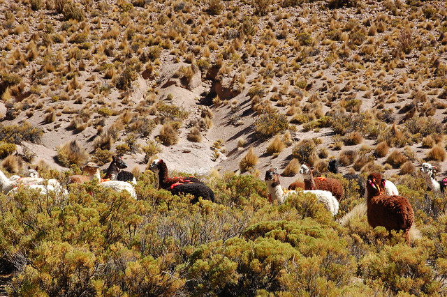
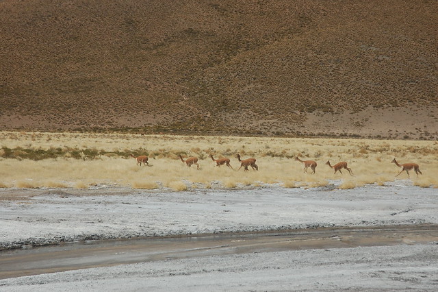
At this point, we were high in the Chilean altiplano (highlands), and it was time to go off-roading. While Ruta 15 continues towards the Bolivian border, the interesting sites lie on the dirt roads running parallel. You start to see another type of traffic, animals like llamas, vicuña, and other cameloids making their way across the high altitude vegetation.
Appreciating the Chilean Altiplano
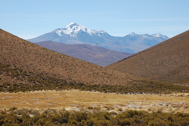
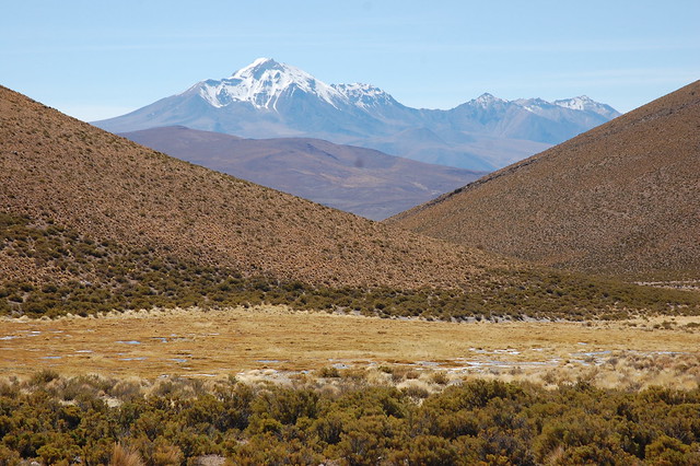
And then there were the views. I loved seeing the volcanos and snow-covered mountains appearing and disappearing as we rounded corners and headed deeper into the altiplano. Without any lakes around, the landscape was colored in sun-toasted earth tones.
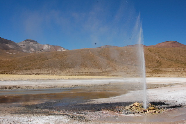
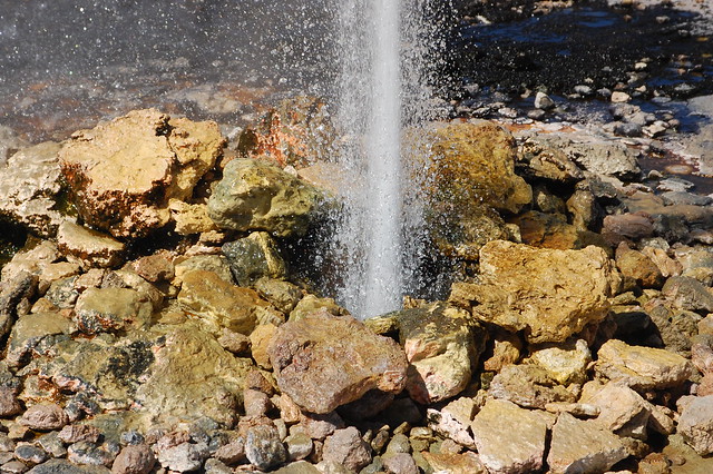
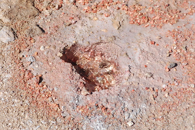
Geisers de Puchuldiza
Geisers de Puchuldiza
Our next stop after admiring the landscape and wildlife was the Geisers de Puchuldiza. These geysers are not naturally occurring; the holes in the earth were left open after some sort of mining activity and the water forces itself out due to the pressure beneath the earth’s surface.
Selfie at the Geisers de Puchuldiza
There are several spots where the boiling hot water rises to the surface, and the most interesting is where the water comes out with such force and heat, but freezes into this large ice formation in the winter cold of the high Andes. The ice surface glows bright white in the sun, and if you stand close to it you might think you are in Antartica.
Geisers de Puchuldiza
Watching the steaming water spring out of the ground is entertaining for a little while, appreciating nature’s force and reminding you that there is more going on beneath us than we usually consider.
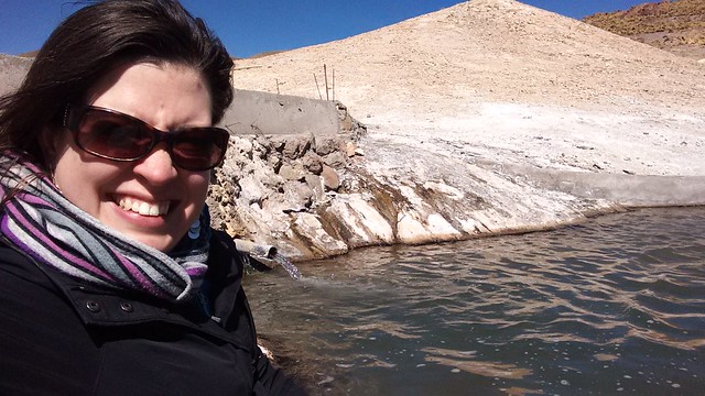
Termas de Puchuldiza
From there, we walked over to the Termas de Puchuldiza, a very basic thermal bath built in the middle of nowhere in the Chilean altiplano. At this altitude, the air is cold, but even still I was convinced to change into a bathing suit and get into the healing waters.
Termas de Puchuldiza
I have to say, after this trip, I am now a big fan of thermal baths, whereas before I didn’t quite understand their appeal. While I’m not sure if the stories about the healing properties of the mineral waters are true, it is relaxing to hang out in a hot pool in the middle of winter. I was especially appreciative to spend some time talking with the other people on my tour and learning their stories.
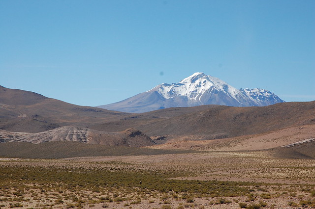
More Views of the Chilean Altiplano
After leaving the thermal baths, we got back in our car, and before long, we hit a road bump – other trucks passing by signaled at our tires, and it turns out that we had a flat.
Appreciating the Active Volcano in the Chilean Altiplano
Good news is that our guides were prepared and were able to change the tire quickly. In the meantime, I wandered into the landscape a bit to take the pressure off them and snap some shots of the beautiful scenery from another angle.
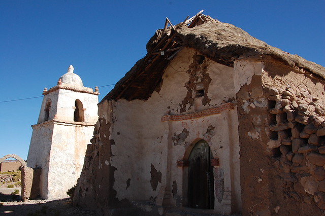
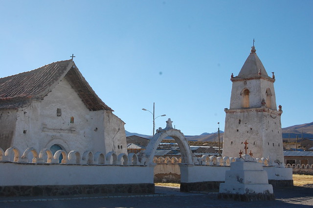
Mauque
Church of Mauque
Tire replaced, we continued our route to Mauque, one of the traditional Aymara towns located near Parque Nacional Isluga. Mauque is notable for its very old, traditional church and the old-fashioned construction of its houses.
Church of Mauque
Unfortunately, for some reason, the local government decided that the old-fashioned plaza of Mauque needed to be modernized. Take a look at the tire marks on the ground. On the morning of our visit, the Chilean authorities bulldozed the plaza to make room for a new one.
The town already has a steel monstrosity of a soccer field in the middle of town. Imagine that – a traditional Aymara town being forced into modern buildings and structures. When we arrived, two of the older townspeople were sitting in the plaza, shocked by the destruction of their plaza. As our guide said, a modern plaza would completely throw off the feeling of the town, and even reduces its appeal to tourists.
Unfortunately, this kind of “development” is fairly common throughout Chile. Character and history give way to uniformity.
In any case, there are artisans in Mauque who offer their hand-knit and woven alpaca products to tourists, if you’re interested in purchasing directly from the makers. After Mauque, we also made a stop in Enquelga, where we saw one of the artisans at work, spinning alpaca yarn. She offered a number of beautiful shawls at low prices; you can see what I ended up purchasing in one of the photos below.
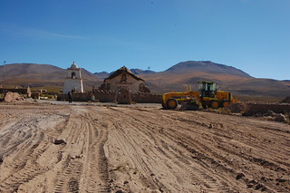
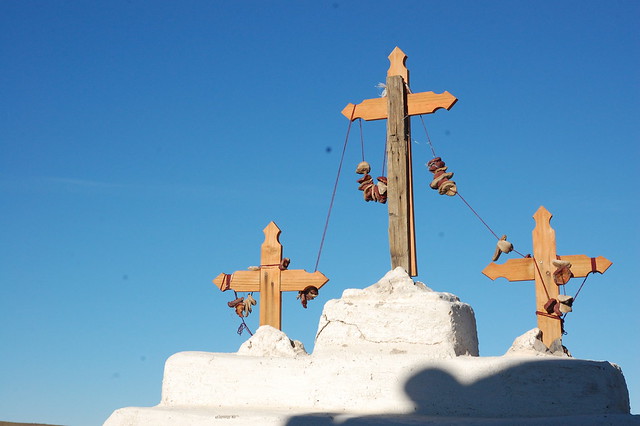
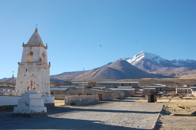
Ceremonial Village of Isluga
Ceremonial Village of Isluga
Finally, in late afternoon, we arrived to Isluga. Isluga is a ceremonial village, which means that its houses are only inhabited during religious events (more information in Spanish here). It’s a little strange to see so many streets filled without houses, but no people.
Ceremonial Village of Isluga
Hanging from the crosses are pieces of fruit which appear to have dried in the sun and cold. These types of offerings are commonly seen throughout the Andes, although I am not exactly sure what they represent.
Ceremonial Village of Isluga
It was quite peaceful to take in the picturesque location of the town, so close to the mountain which plays an important role in Andean philosophy (cosmovisión).
Ceremonial Village of Isluga
Laguna Arabilla in Parque Nacional Isluga
Laguna Arabilla, Parque Nacional Isluga
Our final scenic stop was the one that originally drew me in: the promise of high altitude lagoons. I was not disappointed. This is the sector protected by Parque Nacional Isluga. Because these lagoons are the habitats of flamingoes and other native species, the Chilean national park service has constructed an educational walk around the lagoon, restricting you to the path in order to protect the ecosystem.
Laguna Arabilla, Parque Nacional Isluga
Due to the late hour, we didn’t have much time at Laguna Arabilla, but it was quite lovely. Coming from the desert mountains of the Valle de Elqui and a week spent on the coast, this landscape was a big change and I had more appreciation for its beauty than I may have if I had come directly from a tour of the Salar de Uyuni or San Pedro de Atacama.
Posing at Laguna Arabilla, Parque Nacional Isluga
In any case, I enjoyed the drastic change from the desert and expanding my knowledge and understanding of the geography of Chile. The Andes are amazing.
Colchane
Posing at the Paso Frontizero Colchane, at the Border with Bolivia
After covering so much territory in one day, it was time for an extremely late lunch at Colchane, the last Chilean town before the Bolivian border. Of course, we couldn’t resist taking pictures of the distances to the nearest Bolivian cities!
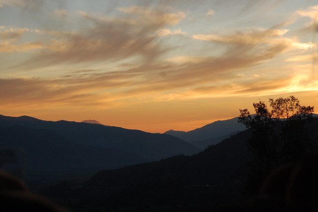
Sunset in Parque Nacional Isluga
After finally eating a real meal, we piled back into the van for the long trip back to Iquique. As night fell, our guide began to tell us about his experiences with the supernatural at oficinas salitreras like Humberstone. It was almost like being around a campfire, swapping stories, where everything seems a little more possible at night than you would believe by the light of day.
I arrived back in Iquique feeling inspired by my visit to the highlands, intrigued by all the history I know so little about, and motivated to keep on exploring and keep on sharing what I learn. I am very thankful to our tour guide for having so much passion for his home region and sharing it with us!
As you can see, I highly recommend heading out on this tour, not just for the beautiful landscapes, but for the opportunity to get a glance into ancient history encoded in the desert, the lives of Aymara villagers, and to just appreciate how different life is at this altitude.
Recommendations for Parque Nacional Isluga Tour, Tarapacá, Chile:
Take the tour! This tour is absolutely worth the money, especially if you are visiting from other parts of Chile where the landscape is really different. The tour uses an off-road readyh vehicle that allows you to visit the more out of the way sites, like the geysers. I booked my tour through the hostel I stayed at in Iquique, who work with Show Travel. I really appreciated the insight of my guide, but he was working on starting his own agency and may no longer work there. Fair warning: most tour guides do not speak much English in this region, and you will get the most out of the tour if you make an effort with your Spanish. The tour cost $45000 CLP in July 2015.
Keep in mind that you go from sea level to over 4000 meters above sea level in a very short period of time, which can be hard on your body. To avoid altitude sickness, the tours serve only cookies and crackers on the tour until about 6PM, when you reach Colchane and have a real meal. You may want to bring some fruit if you want some healthy sugar rather than the processed cookies, but I was advised several times not to eat too much as altitude sickness in this particular region can be especially brutal.
Make sure to bring some extra cash to buy any of the woven goods sold in Mauque and Enquelga. I bought a hand spun and woven alpaca shawl for $25000 CLP, which is incredibly inexpensive for the quality of the weaving and the material. You can see the shawl in the border photo above. It is one of my favorite souvenirs ever and is incredibly warm due to the alpaca wool and the tiny, tight woven stitches.
If you are a vegetarian, the hotel/restaurant in Colchane can serve you a vegetarian option but make sure to tell your travel agency and guide that you need a special meal.
Be sure to bring your bathing suit for the Termas de Puchuldiza. Having just visited Mamiña, I chose not to and immediately regretted it. Luckily, one of my fellow tourists had an extra outfit that they lent me.
Be prepared to spend the entire day in the tour van – I was picked up at 6:45AM and returned to my hostel at 10:00PM.
This video, made using Google Earth, gives a really interesting view on the Gigante del Atacama.
In my year living in the Valle de Elqui, one of my favorite activities was heading out into the orchard to see what fruit was coming into season and to pick a few figs, avocados, grapes, whatever was ready. One of the best things in the garden was the lime tree, filled with the kind known as limón de pica in Chile. (These small, round, green key limes are just called limones in Peru because they are basically the only type of limes or lemons you can find. Chile’s limones are oval and usually mostly yellow – what Americans know as lemons.) After the heavy rains last summer, I gathered up several kilos of limones de pica that had fallen off the tree and enjoyed them for the next couple of months. Suffice it to say, I’m a fan.
In any case, in Chile, the limón de pica was given its name because it grows extensively in and around the town of Pica, located in the region of Tarapacá, in northern Chile. Only a couple of hours away from the busy city of Iquique, easily accessible by public bus or car, it is a popular destination for Chilean tourists.
Inside the Iglesia de San Andrés in Pica, Chile
The route from Iquique to Pica climbs up the cliffs to Alto Hospicio (where I snapped this picture), and continues along Ruta 16 towards the Panamerican Highway, about an hour inland. On the way, the highway passes Humberstone before arriving to the crossroads town of Pozo Almonte, right on Ruta 5 (the Panamerican). Every bus stops in this transit center, where you can transfer to another if necessary. Leaving Humberstone, I flagged down a bus heading to Pica and was able to snag a seat once half the passengers descended in Pozo.
From there, it’s about an hour to Pica, an easy ride through the desert. On the way, you pass through La Tirana, a small town known for its famous religious festival celebrating the Virgen de Carmen. The festival is celebrated from July 12-18 and is attended by thousands of people every year. This celebration is particularly famous in Chile because it is the most traditionally Andean of any in the entire country; the dances are extravagant, fascinating, and entertaining. While I visited the area in July, I arrived just after the festival had ended, so had to settle for watching videos in the Museo Regional de Iquique. That said, on my way through, the small town was still doing a brisk business selling religious trinkets and welcoming quite a number of tourists.
Stained Glass in the Iglesia de San Andrés, Pica, Chile
After passing through La Tirana, we continued heading through the desert, but as we approached Pica I started noticing the various patches of bright green foliage. Pica is famous because it is a pleasant oasis in the middle of the large northern desert, which makes it a great place to grow hot climate fruit like mango and citrus. And that was basically the reason I went there – to eat delicious fruit. What can I say, I’m a simple person.
Stained Glass Reflections, Iglesia de San Andrés, Pica, Chile
The bus route ends at the central plaza of Pica, where the first thing to catch your eye is the gorgeous Iglesia de San Andrés, as you see in the photos above. This church is prized in northern Chile for its traditional construction and attractive interior. I was particularly fascinated by the rainbow reflections of the stained glass windows, as you can see from the photos.
Main Plaza of Pica, Chile
After checking out the cathedral, I walked around Pica’s main plaza. As mentioned, Pica is an oasis, which means it has a much more agreeable climate than the relentless sun of the open desert. After spending the morning exploring Humberstone, I was more than ready to cool off in the plaza. And to be honest, that is basically all there is to do in Pica: sit in the pleasant plaza to while away an afternoon.
Pretty Streets of Pica, Chile
Pica has a number of old, traditional houses painted in bright colors, inviting you to admire them. The main road hosts a library, several hotels, and a couple of stores offering Pica’s other specialty, alfajores de Pica. The town is small, so it’s easy to wander around without getting lost.
If you continue along Calle Esmeralda, the main thoroughfare heads to Cocha Resbaldero, Pica’s other main tourist attraction besides the church and the fruit. Cocha Resbaldero is a natural pool or thermal bath formed out of volcanic rock, popular with tourists interested in taking a nice relaxing dip. As I was heading to Mamiña for its healing mineral waters the next day, I opted to skip the crowds (which you see here!).
Artesanal Fruit Ice Cream in Pica, Chile
After sufficiently ascertaining that there was not much to do in Pica (and finding that there was not fruit on every corner as I expected), I headed back towards the main plaza. After poking around some more, I found a pleasant restaurant offering fresh juices and fruit by the kilo. I bought some early-season mangos and toronjas (grapefruit) and then headed back to a little storefront offering homemade ice cream. As I am on a mission to try artesanal ice cream in every small town where I find myself, I couldn’t resist and tried out mango and guayaba (guaba).
Alfajores de Pica, Chile
Before leaving Pica, I bought a couple of packages of alfajores de Pica, which differ from the usual alfajores due to the slightly different technique used to make them. Alfajores de Pica have crispy cookie layers and are usually filled with mango jam rather than the traditional manjar. They may also be rolled in coconut, completing the tropical flavor.
If you decide that it’s not worth trekking all the way out to Pica just to buy some alfajores, they are often sold by vendors at the transit hub of Pozo Almonte and can be found in supermarkets in Iquique. Similarly, there are juices made with fruits from the region at the Mercado Centenario. Either way, visiting Pica makes for a pleasant day trip when combined the nearby attractions of Humberstone and La Tirana; visiting the oasis provides a nice break from the surrounding desert.
Recommendations for Pica, Tarapacá, Chile:
Buses to Pica leave from the 700 block of Barros Araña near the Mercado Centenario in the center of Iquique. Before arriving in Pica, they pass by Humberstone and through Pozo Almonte and La Tirana. You can get on and off the buses at any of those stops (or anywhere else on the route). A bus to or from Iquique costs $3000 CLP. From Humberstone, the bus costs $2000 CLP. You can buy your return ticket at the bus stand next to the main plaza, where you see all the buses parked.
If you are interested in swimming in Cocha Resbaldero, make sure you arrive earlier in the day to give yourself enough time to walk over there and enjoy a relaxing dip. The pool is really popular with Chilean tourists so it may be better to visit on a weekday. The pool costs $2000 CLP.
There are a number of restaurants in Pica but as it is a small town, they only appear to be open during the lunch hour. I found one restaurant serving juices in late afternoon but there were no other customers inside.
You can buy alfajores de Pica at the factory on the corner of the plaza, across from the church. The older gentleman who sits outside the factory is a local celebrity and the walls are covered with articles describing the alfajores and other aspects of town life. There is another factory selling alfajores a block or two from the plaza.
Although Pica was a pleasant place to visit for an hour or two, I would definitely suggest combining it with a stop in Humberstone and La Tirana to make the most out of your day.
Now that I’ve had a chance to end my time in the Valle de Elqui, travel around southern Chile, and decide to move back to Peru, it’s time to rewind to where it all began last year: my inspirational trip to the region of Tarapacá and the sites around the amazing city of Iquique.
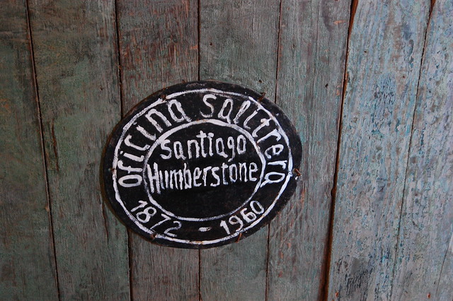
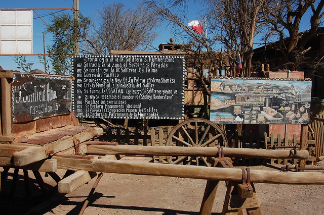
Timeline of the History of Oficina Salitrera Humberstone
If you think about it, it’s quite fitting that my trip to Iquique was one of the first steps towards heading back to Peru. The region used to be Peruvian territory until the Guerra de Pacífico (the War of the Pacific) between Chile, Peru, and Bolivia, which resulted in a treaty that ceded Tarapacá to Chile in 1883. While military history is not my strong suit (and for a much greater understanding of this conflict I highly recommend The Chile Reader, a book containing primary historical documents translated into English), this war was also known as the Guerra del Guano y el Salitre, two valuable materials used as fertilizer in this era and the financial impetus for the conflict. (For the record, guano is bird manure and salitre is saltpeter.)
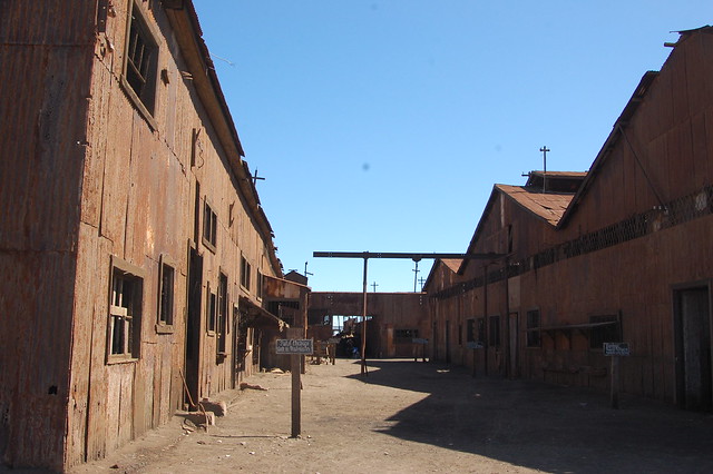
Abandoned Buildings in Oficina Salitrera Humberstone
And that brings us to salitre, or saltpeter (potassium nitrate), a mineral that was once found in massive quantities in the deserts of northern Chile. In its heyday, saltpeter was a highly valuable, in demand natural fertilizer exported all around the world. As Chile is a country which owes a great deal of its wealth to mining, it follows that Chilean industry would seek to exploit this natural bounty. And exploit it did: the regions of Tarapacá and Antofagasta were once home to hundreds of oficinas salitreras, or saltpeter mines. (Wikipedia has a full list.)
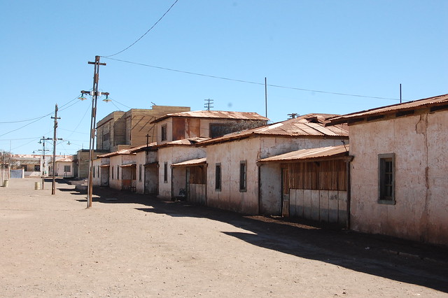
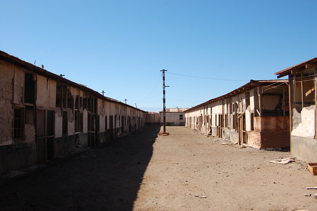
Housing Sector in Oficina Salitrera Humberstone
For anyone truly interested in understanding the history of northern Chile and the role that mining has played in generations of families, you have to educate yourself on what the life of a Chilean miner has been and currently is like. In the Valle de Elqui, almost every family I knew was touched by mining, where a father or son or partner or cousin heads north to Antofogasta or Tarapacá on a regular basis. Miners generally work in cycles where they will spend 10, 12, or 14 days working in the mines and an equal number on descanso (rest) back at home. While Los 33 is a dramatized Hollywood version of a particularly challenging episode in Chilean mining history, it can serve as an easily accesible visual introduction to life underground.
Athletic Courts in Oficina Salitrera Humberstone
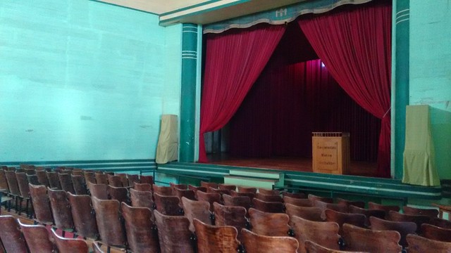
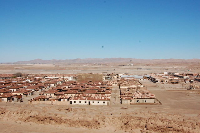
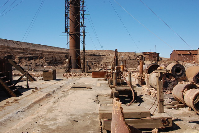
In the heights of the saltpeter industry, entire complexes grew up around the mines, located in the most inhospitable parts of the north, baking under the desert sun. Some of the salitreras were small and consisted of little more than the industrial operations and basic housing, but others, like Oficina Salitrera Humberstone, evolved to have extensive living complexes, a hotel and bar, swimming pools and basketball courts, schools, and even a theatre.
Crumbling Buildings in Oficina Salitrera Humberstone
According to what locals told me, Humberstone was actually quite unusual, serving as the “model” saltpeter mine, but that doesn’t make it any less interesting. It just makes you realize that if you think these conditions are harsh, they were much worse in most of the other oficinas.
One of the Few Shaded Places in Oficina Salitrera Humberstone
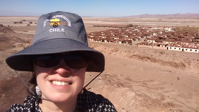
I didn’t know what to expect when arriving at Humberstone, known as an abandoned yet amazingly preserved national monument recognized by UNESCO. I took one of the frequent buses from the Mercado Centenario in the center of Iquique and was deposited at the bus stop on the recently relocated highway. While the highway used to pass right next to Humberstone, now you have to walk about 10 minutes to get to the entrance.
Humberstone’s Theatre, the Center of Social Life in the Mining Complex
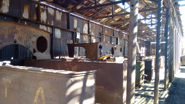
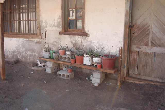
After paying the entrance fee, I received my map of the massive site and started wandering around. There is a lot to see. If you are fascinated, as I was, by all the history contained within the site, you could easily spend the entire day there, wandering through the buildings on the main square, poking around the main “streets” containing the living barracks, checking out the various on-site museums displaying wooden doors and windows, household goods, tools used by the miners, or games created by the children.
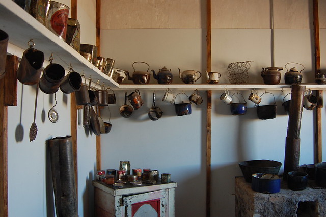
Kitchenwares Once Used by Residents of Oficina Salitrera Humberstone
It’s definitely worth contemplating what life was like for so many men, women, and children for decades, living in this hostile climate and having to find a way to adapt to this lifestyle in order to eke out a living.
Posing in the Old School at Oficina Salitrera Humberstone
As a teacher myself, I appreciated walking through the old school and picturing the children trying to imagine their futures beyond the pampa (desert mine region), living in a bleak environment. One of the classrooms displays enlarged pages containing an excerpt from a book written by a man who grew up in the saltpeter mines, illustrating the harshness of life for women and children.
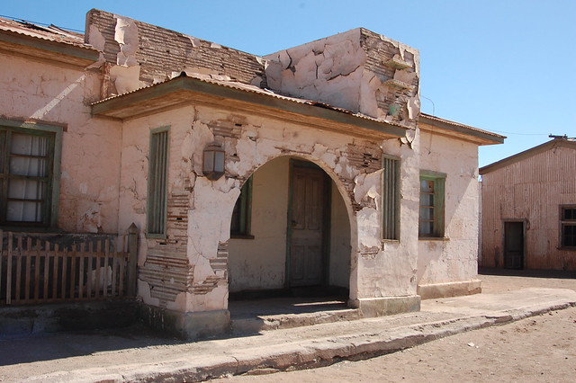
Old Administrative Offices at Oficina Salitrera Humberstone
Old Mini Railroad to Transport Saltpeter at Oficina Salitrera Humberstone
After walking through the streets of the residential sector, I explored the homes of the higher ranking managers and the relative comforts of their quarters and administrative offices. Many of the museum exhibits are housed in these sturdy, well-preserved buildings.
Climbing the “Torta” or Mountain of Industrial Residues from Saltpeter Extraction at Oficina Salitrera Humberstone
From there, I climbed to the top of the “torta” or the mountain created by the residues from the mining process. This provides an amazing vantage point over the entire area, giving a clear view of the vastness of the mine.
Views of Oficina Salitrera Humberstone from Above
Looking from the uniform residential buildings (still echoed in the suburban Chilean landscape today), to the towers of nearby Oficina Santa Laura, to the sprawling industrial sector littered with abandoned machinery, I was able to construct a visual of what the area must have looked like a century ago and how lonely it must have felt to live and work here. The expanses of the desert are impressively vast. You can barely make out the highway from the highest vantage point. The sense of isolation is complete.
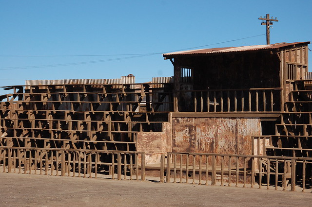
Industrial Sector at Oficina Salitrera Humberstone
After sufficiently appreciating the view and being thankful for the opportunity to develop a deeper understanding of life here, I headed over to the industrial sector, observing the heavy machinery and getting a sense of how saltpeter was processed.
Industrial Sector at Oficina Salitrera Humberstone
To be fair, I was much more interested in the residential area because it baffled my mind to imagine people living here for as long as they did. Not just here, but in any of the many abandoned oficinas you can see from the highway as you travel around the region.
Industrial Machinery at Oficina Salitrera Humberstone
The really ambitious independent traveler can continue exploring Oficina Santa Laura, another nearby saltpeter mine about 20 minutes away on foot. I wanted to continue on to Pica before it got too late in the day (and needed a break from the sun), so I skipped it this time around.
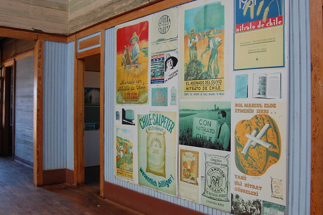
Old Posters Promoting Chilean Nitrate/Saltpeter in the Museum of Oficina Salitrera Humberstone
For what it’s worth, people say that you can feel the spirits of ghosts while wandering through the abandoned mining complex. Some tour agencies even offer nighttime full moon tours for just this reason. I spoke to a local tour guide who told me that there are definitely spirits still inhabiting other mining complexes, especially those where conditions were more brutal and more lives were lost. I found it particularly moving to hear the stories of these spirit encounters and imagine these poor souls still wanting to tell their stories.
Bringing Life Back to Oficina Salitrera Humberstone
Whatever your beliefs, I think it’s important to honor these workers of the past and how their sacrifice and dedication contributed to the development of Chile. My visit to Humberstone gave me a greater appreciation for the realities of mining and brought me to a deeper understanding of Chile and its culture. I highly suggest a visit. I went independently, which gave me much more time at the mining complex and enabled me to read the plentiful, informative signage (often in Spanish but sometimes in English) and spend more time appreciating the entire site.
Posing Above Oficina Salitrera Humberstone, Thankful for the Opportunity to Learn
Recommendations for Oficina Salitrera Humberstone, Tarapacá, Chile:
Humberstone is easily reached via public transportation. Buses leave every few minutes from the 700 block of Barros Araña, near the Mercado Centenario in Iquique. A bus to Humberstone from Iquique cost $2000CLP in July 2015.
Make sure to tell the driver that you will get off in Humberstone, as the buses continue on to more distant destinations, and only tourists stop in Humberstone. The highway exit is incredibly well labeled and visible, but you can always follow the route on Google Maps if you want to make sure you don’t miss it!
Upon arrival, cross the highway via the overpass and keep walking to the visible parking lot. The entrance is well labeled and easily to find. Entry to the site costs $3000CLP and includes a map of the complex.
The map gives a good sense of the layout of the site. I started with the main plaza, headed through the residential sector, climbed the “torta,” and then saw the administrative offices, before heading to the industrial sector. On my way back, I wandered through the exhibits lining the main road. Due to the exhausting nature of being in the sun for so long, I also suggest heading to the farther sector first and working your way back, ending with the indoor museums.
Do not forget sunblock, and if you don’t have a hat, you can buy one at the artisan stands located on site. The sun is brutal. Just imagine living here!
You can walk to Oficina Santa Laura from Humberstone if you are interested in seeing another site. Oficina Santa Laura gives a clearer sense of the industrial aspect of the oficinas.
From Humberstone, I headed onward to Pica by waiting at the same bus stop I got off at. You can also visit La Tirana on the way to Pica. If you want to squeeze all three locations into one day’s trip on public transportation, leave Iquique by 8 or 9AM to give yourself enough time to explore.
For more information on the saltpeter mines, give yourself time to explore the many on-site museums and displays. This BBC article gives a little more context on the mining complex. This interesting article explains how important saltpeter used to be.
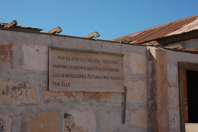
Out of pride of being pampino (Saltpeter Miners), let’s take care of our heritage as future generations will judge us for it
When I decided to travel to Iquique, I knew one of my stops would be Mamiña, a small town in the desert known for its healing mineral waters. According to the legend, an Incan princess named Mamiña recovered her sight after washing her eyes with the water that flows through the town. Today, Mamiña is a popular stop for miners seeking to relax their tired muscles and people treating a number of health complaints. It is also a common day trip for your average tourist like me, looking for a relaxing soak in thermal baths.
Church in Mamiña, Tarapacá, Chile
Throughout my travels through South America, I have taken many a thermal bath and elected to skip several others. In Cachueta, near Mendoza, Argentina, the thermal waters give a sense of luxury among the picturesque Andes. In Baños del Inca, near Cajamarca, Peru, a rather sterile complex has grown up around one of the Inca’s favorite places to relax, where the thermal water is piped into a tiny cell-like bathing room. I wasn’t sure what to expect in Mamiña.
Plaza in Mamiña, Tarapacá, Chile
Although tours can take you to Mamiña, they cost between $25000-$35000CLP per person, which is quite pricey for someone on a nonprofit salary. Beyond that, I wasn’t that into sharing a relaxing bath with other tourists. After a little bit of research, I discovered that public buses to Mamiña leave daily from just outside the Mercado Centenario in the center of Iquique (see details, below).
Road in Upper Mamiña, Tarapacá, Chile
The route passes through Pozo Almonte en route to Mamiña, giving you a chance to buy breakfast in the dusty transit town. From there, it is a mostly paved road to Mamiña and a steady climb in altitude. The bus first stops at the plaza of Mamiña, which hosts an attractive old church. Don’t make my mistake and attempt to get off there; the town is separated into a lower and upper section and the bus will take you all the way to the thermal baths above town.
Barros Chinos, Mamiña, Tarapacá, Chile
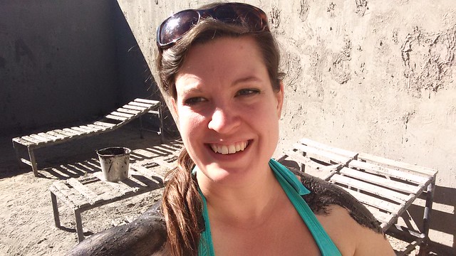
By the time we arrived, it was about 11AM, which is a good time to get there as the sun was just starting to get strong. The bus dropped us off at Barros Chinos, where I got ready to take my first ever mud bath.
Barros Chinos, Mamiña, Tarapacá, Chile
After paying a $3000 entrance fee, the gentle, friendly staffperson points out the changing rooms and the mud bathing rooms, one for women, men, and mixed, for families. I headed into the women’s bathing room, where the attendant brought me a bucket of mud and kindly offered to apply it to my back as I was on my own.
Coating Myself in Mud at Barros Chinos, Mamiña, Tarapacá, Chile
The instructions are simple: coat yourself all over with mud and sit in the sun for 30 minutes to let it dry. When I started slathering the mud on, I started laughing so hard tears ran down. I never thought I would voluntarily coat myself in mud! Other ladies came in and told me that the mud was supposed to be good for your hair and skin. I wasn’t quite ready to put it in my hair but I tried it on my face, which the nice man captured for posterity.
Thermal Bath at Barros Chinos, Mamiña, Tarapacá, Chile
After 30 minutes, I was antsy and ready to get into the thermal bath itself. Despite the strong sulphur smell, the bath itself is a pleasant temperature, with pockets of water which almost burn your feet. The pool you rinse off in is actually just carved out of the ground and you definitely touch the mud bottom. Not for the squeamish.
Barros Chinos, Mamiña, Tarapacá, Chile
After stepping out of the thermal bath, I attempted a quick rinse under the frigid showers and changed back into my clothes. I had a couple of hours to kill by wandering through the residential part of town and eating my lunch. There are few places that offer lunch, so as a vegetarian, I opted to bring my own food.
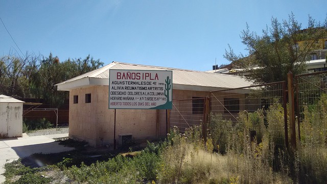
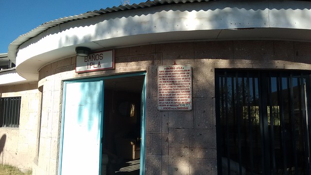
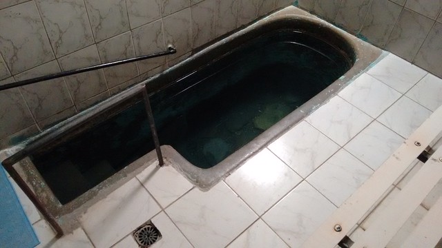
Baños Ipla, Mamiña, Tarapacá, Chile
After the traditional siesta, Baños Ipla opens back up for business. I was one of the first ones through the door and headed into my own private room, which is basically another thermal bath carved into the floor. Because the baths are sourced right out of the ground below, the water which comes in is full of what looks like dirt and minerals. And the water is hot. Seriously hot. Signs around the small complex recommend a bath of only 5 minutes, and up to 10 minutes for later visits, once your body has built up tolerance.
Private Thermal Bath in Baños Ipla, Mamiña, Chile
Take this advice seriously – submerging in water this hot is no joke. After your five minute dip, you should rest for about 10 minutes on the wooden recliner. After so many months feeling cold, it was an amazing feeling to be so warm, right through to my bones. I needed the recovery time to stretch out my muscles and let my blood pressure return to normal. Afterwards, you head out into the waiting area to let the relaxation set in a little more.
Around this time, a local came by to the little stand outside the bath complex, offering delicious fresh juices. I opted for guayaba, since it’s not a fruit I see too often.
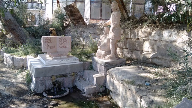
Source of the Healing Waters of Mamiña, Tarapacá, Chile
After enjoying my juice, I walked behind Banos Ipla to see the small monument to the site where Mamiña had her vision restored, which would have been a relaxing place to read if it weren’t for the construction going on at the hotel a stone throw’s away.
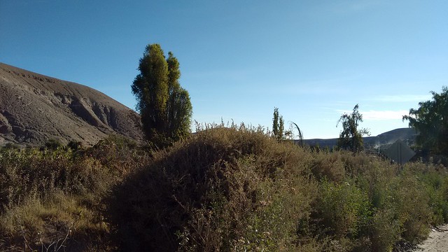
Green Hills around Mamiña, Tarapacá, Chile
The rest of the afternoon was laid back, with those of us who had come in on the bus waiting around Baños Ipla until it was time to catch the bus back to Iquique. It was a pleasant afternoon, definitely at the Chilean pace, where there is nothing in particular to do, so you get the chance to embrace downtime.
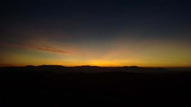
Sunset Over the Desert in Tarapacá, Chile
Recommendations for Mamiña, Tarapacá, Chile:
Tours to Mamina are available from various tour operators in Iquique and cost between $25000-$35000CLP per person. However, I suggest visiting Mamiña independently.
Public buses run daily to Mamina from the 900 block of Barros Araña, next to the Mercado Centenario in Iquique. You can buy tickets in advance from the store at Barros Arana 965. You may also be able to arrange other pickup locations with the driver, and the bus also stops in Pozo Almonte. Each way costs $4000CLP per person, or roundtrip for $8000CLP. Buses leave at 8AM and leave upper Mamina at 5:30PM and the plaza of Mamina at 6PM. (There is also an afternoon bus at 4PM from Iquique which returns from Mamina at 8AM.)
There are a few pricey hotel complexes in Mamina, popular among miners, families, or people using the water for treatment. There are a few restaurants with cabins (cabanas) scattered around, but it is best to try to make reservations or check if they are serving food on less busy days.
Bring snacks and water as there are not many places to buy refreshments.
Make sure you take advantage at the stop at the plaza to check out the church.
I might as well get it out there: I loved, loved, loved Iquique. Iquique is a uniquely situated city; it rests steps away from the ocean, yet is also only a short climb down the sand dunes from the inland desert, home to the saltpeter mines which boosted Chile’s economy for a century. Once the site of many a territorial dispute and their ensuing battles, Iquique is currently only a few hours away from both the Peruvian and Bolivian borders, meaning it has many immigrants and much cultural influence from its neighbors. On top of that, it is an active port city which has become famous in recent years for its surfing and paragliding, increasing its popularity among tourists who come for its great weather and traditional architecture reflecting the British influence from the mining heyday.
Iquique Coastline
Iquique has been on my radar since 2013, when I spent a few days appreciating Arica. Instead of exploring along the Chilean coast, I headed inland to the Atacama desert to realize one of my travel dreams of finally seeing the landscapes around San Pedro de Atacama. I figured I could head to Iquique on my way back through Chile later in my trip, but I ended up skipping it.
Views from a Bus Climbing the Dunes Above Iquique, Chile
However, after suffering through the chilly desert nights in the Valle de Elqui, I was more than ready for some warm beach temperatures during my winter vacation in July. After saying goodbye to Sara, my partner-in-crime for adventures in Santiago, Viña del Mar, and Isla Negra, I headed north to Caldera, where I spent a weekend before moving on to my final destination, Iquique.
After an arduous bus ride through the inland desert, I finally arrived in Iquique. Since it was late afternoon, I headed directly to my hostel, Hostel El Bajo, located just a block from the ocean. A family-run hostel popular with surfers, I felt like I was part of the group immediately upon arrival and decided to stay for the rest of my vacation, giving me time to fully explore the city as well as the sights of Tarapacá: Oficina Salitrera Humberstone, the oasis of Pica, the healing thermal baths of Mamiña, and Parque Nacional Isluga.
I spent most of my time in Iquique wandering the streets and along the coast, taking in the city’s ambiance and thinking about moving here after I finish my year in the Valle de Elqui. Here are some of the places I think are worth checking out in Iquique.
Baquedano and the Plaza de Armas
Sunny Day on Baquedano, Iquique, Chile
Baquedano is the main pedestrian thoroughfare in downtown Iquique precisely because it is exclusively for foot and bicycle traffic. Restaurants, hostales, and tourist agencies dot the cobblestone roads and wooden sidewalks, many of them brightly painted in colors that show off their attractive wooden balconies. Sadly other buildings are falling apart from neglect or leftover damage from the 2014 earthquake.
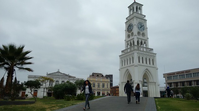
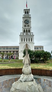
Torre de Reloj, Plaza de Armas, Iquique, Chile
Since I was staying by the beach, I chose to walk along Baquedano to the commercial center of town, the Plaza de Armas. In the middle of the Plaza de Armas stands the Torre de Reloj, or clock tower, one of the distinctive features of the main square.
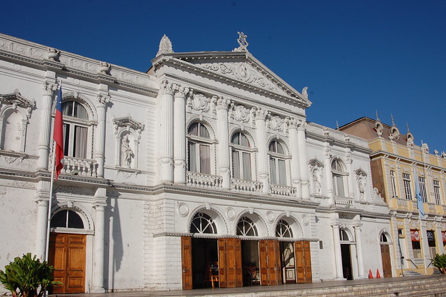
Teatro Municipal, Iquique, Chile
Just next to the Plaza de Armas is the Teatro Municipal, a bright white building reflecting the grandeur of Iquique’s lucrative past.
Due to its popularity among tourists, there are many cafés and restauarants all around this part of Baquedano and the surrounding side streets, providing a nice place to relax and people watch.
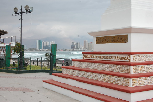
Iquique has a large number of Croatian immigrants, who even have a cultural club right on the main plaza.
This part of Iquique is particularly busy with business, as there are banks lining the nearby streets, as well as the municipal buildings and other tourist services. Chances are, if you need it, you can find it near here!
Baquedano, Iquique, Chile
The colorful buildings are especially pleasant to look at on a sunny day, but unfortunately there was not that much sun during my visit. Even still, I admired the well-preserved wooden balconies and construction throughout the downtown area.
View of Baquedano from the Museo Regional, Iquique, Chile
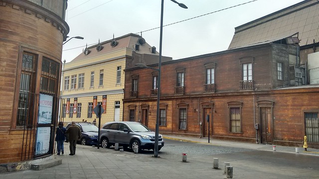
Traditional Wooden Buildings Near the Downtown Area of Iquique, Chile
Just a couple of blocks from Baquedano is this traditional neighborhood, boasting wooden construction which still looks pretty awesome after all these years.
Museo Corbeta Esmeralda and the Industrial Port
Museo Corbeta Esmeralda, Iquique, Chile
Near the busy bus terminal lies one of Iquique’s most popular museums, a reconstruction of the famous ship called Esmeralda. This ship was sunk by the Peruvian navy during the Battle of Iquique and as such serves as a national symbol of Chile’s military pride.
The museum was packed with visitors as it was during winter vacation, and it is generally best to reserve a time slot in order to tour the ship. Although I was curious, I was more interested in exploring the rest of the city so I decided not to wait in the long line.
Port Views from Iquique, Chile
Behind the Museo Esmeralda and the bus terminal, you can check out the commercial port, albeit from a distance. It gives you a sense of the massive amount of commerce that passes through Iquique and has made it such an important city in the Chilean economy.
Museo Regional Iquique
Museo Regional de Iquique and Photos of the La Tirana Festival
After wandering around downtown a bit, my curiosity in the history of Iquique was definitely piqued, so I headed to the Museo Regional de Iquique, located on Baquedano. The museum is completely free and has permanent exhibits on the indigenous populations that resided or still live around Tarapacá and on the saltpeter mining industry which dominated the nearby desert for over a century.
At the time of my visit, the museum also had an interesting photography exhibit and video presentation representing the Fiesta de La Tirana, a major cultural and religious event that had taken place in nearby La Tirana in mid-July. It is known especially for its traditional dances and costumes representing the Diablada, or the Devil’s dance.
Relics of the Saltpeter Mining Industry in the Museo Regional de Iquique
Photos and Facts From the Many Oficinas Salitreras (Saltpeter Mines) in Northern Chile
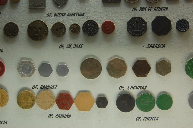
Special Currency Used by the Saltpeter Mines, Museo Regional de Iquique
I was particularly interested in the exhibits on the salitreras, or saltpeter mines, as I was also planning on heading to Oficina Humberstone, one of the best preserved and biggest former mines. Mining is such a major industry in Chile, and the exhibit gave me insight into how the saltpeter and nitrate industry has impacted generations of families in the north.
I was also excited to see the exhibit on textiles from Isluga, where the Aymara still live and weave in the traditional styles used for centuries. This was a nice preview for my visit to the altiplano, or highlands, later that week.
Walking Along Iquique’s Malecón, or Boardwalk
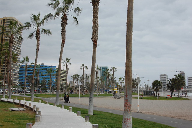
Bike Path and Boardwalk in Iquique, Chile
Naturally, as I was staying just a block from the beach, I had to spend some time wandering along the malecón, enjoying the sound of the waves and the views of the coastline. Iquique’s wooden boardwalk is a pleasant place to walk, and a nice bike path runs parallel along the whole length of the coast.
Monument to Croatian Immigrants, Iquique, Chile
Views of the Ocean in Iquique, Chile
Wooden Boardwalk along the Malecón, Iquique, Chile
Further from Baquedano, towards the casino, the boardwalk turns more touristy, near the most popular beach, Playa Cavancha. Since I went in the off season, most everything was closed up, with the exception of some souvenir stands.
Casino, Iquique, Chile
Looking Back at Iquique’s Coastline
All in all, I enjoyed my lengthy walk along the coastline, even though it was cloudy, windy, and chilly on this particular afternoon. I would love to return in summer and really soak in the beachy vibes.
Mercado Centenario
Mercado Centenario, Iquique, Chile
The center of all commercial activity stems from the Mercado Centenario, located in the middle of downtown Iquique. The market sells fruit, vegetables, dried goods, fish, and lots of other food options, and has a number of restaurants both in and outside the market.
Fresh Juice at the Mercado Centenario, Iquique, Chile
I couldn’t resist a fresh juice at the market, made from the varieties of fruit that grow in the area, like oranges, mangoes, and guavas. Sitting down at an outdoor café with juice in front of me reminded me a lot of the many similar markets I’ve been to in Peru!
Near the market, there are several commercial streets selling just about everything you can imagine, and regional buses leave from a couple of offices just a block away.
Chumbeques
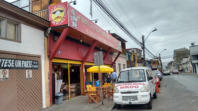
Fábrica de Chumbeques, Iquique, Chile
In my research about Iquique, I came across recommendations to buy chumbeques, super sweet bar cookies produced in Iquique with regional fruit. I headed straight to the factory at Ramírez 795 and tried the crumbly cookie sandwich stuffed with mango.
Chumbeque Souvenirs from Iquique, Chile
I ended up returning to buy a pack of mango chumbeques as well as the traditional one filled with the local limón de pica. These are great snacks for a hike or long trip as they store well and provide a burst of energy.
As you can see, I was charmed by Iquique, because of its beautiful coastline, interesting architecture, multi-faceted heritage, and ambiance that reminds me of my beloved Peru. My adventures around the Tarapacá region continue to inspire me to learn more about Chile’s fascinating history.
Recommendations for Iquique, Chile:
I really enjoyed my stay at Hostel El Bajo, located at Obispo Labbé 1659, just one block from the ocean. It is a family run hostel with a Marley Coffee café inside, and they are avid surfers. The beds are comfortable with high quality mattresses even if the rooms are a bit cramped, and each room has lockers to store your stuff. The kitchen is also well-stocked, which is a great way to save money. In July 2015, a bed in the dorm cost $10000, including a simple but nice breakfast.
The Museo Regional de Iquique, located at Baquedano 951, has a number of exhibits which help you get a sense of the particular aspects which characterize the Tarapacá region, in particularly the saltpeter mines, the La Tirana festival, and the customs of the Aymara living in the high Andes. Entry is free.
The other popular museum in Iquique is the Museo Corbeta Esmeralda, a reconstruction of the famous ship named Esmeralda. You can reserve your visit online, except on Sundays, which is first-come, first serve. The cost of admission for foreigners is $3000CLP.
It is absolutely essential to walk along Baquedano to the Plaza de Armas to get a sense of the old Iquique and its unique architecture. Near the Plaza de Armas, there are a few side streets and markets selling souvenirs and artesanía. It is also possible to take the tourist trolley up and down Baquedano, if it’s running.
No visit to Iquique is complete without a walk along the beach. Iquique has a wooden boardwalk as well as a nice bike path that runs parallel. Playa Cavancha is the most popular beach among tourists, and closer to the casino there are other tourist attractions, although none were operational on my visit.
Iquique is famous for its Zofri, or tax free zone, where people buy all kinds of electronics and perfumes at low prices. I wasn’t that interested in shopping, but if you are, make sure you take a taxi or a bus there as it passes through some undesirable neighborhoods.
The Mercado Centenario at Barros Araña 850 is a great place to have fresh juice or inexpensive sandwiches, empanadas, or fixed price lunches. There are also stands selling fruit, vegetables, and dried goods, and you can also find a lot of products from Peru, like ají amarillo and my favorite Sublime chocolate.
If you’re interested in trying the chumbeque, the locally popular treat that sticks to your ribs, you can buy them at the factory at Ramírez 795, or in many other spots around town. I suggest the mango flavor.
Buses to Humberstone, La Tirana, Pica, Mamiña, and other local destinations leave from the 700 block of Barros Araña, just a block from the Mercado Centenario. Buses to national destinations leave from the bus terminal, near the Esmeralda and the Plaza de Armas.
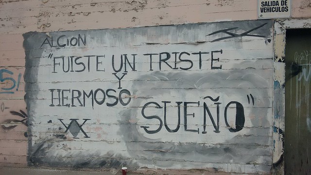
Graffiti in Iquique, Chile: “You were a sad and beautiful dream”
There’s no way around it: northern Chile is vast. Chile is a long, skinny country with miles upon endless miles of coastline, dotted here and there with important port cities or crossroads towns connecting to an inland highway. When heading north from Santiago by land, you may ask yourself one of two questions: can I endure spending 24+ hours on a bus? or, where can I stop?
Quiet Little Beach and Houses Overlooking the Bay of Caldera, Chile
While I spent 32 hours on a bus once before, I vowed never to do that again. When I decided to visit Iquique for the second half of my winter vacation, I knew I wanted to break the journey somewhere along the way.
Plaza de Armas in Caldera, Chile
Enter Caldera. Caldera is about 12 hours north of Santiago and 12 hours south of Iquique and located right off the Panamerican highway, making it an easily accessible and convenient stop on a bus journey along the coast. After hearing rave reviews of the town from two of my volunteers, I decided to see it for myself.
Fishing Boats Docked in Caldera, Chile
Caldera is a town known for its artisanal fishing methods, for being the site of the first railroad in Chile, for its colonial arquitecture, and for its pleasant beaches. By coincidence, I decided to visit Caldera on the weekend it was celebrating the anniversary of the first railroad, which gave the usually quiet town lots of fun energy and life.
Relaxing at the Beach in Caldera, Chile
To be fair, there isn’t much to do in Caldera except relax. I spent some time sitting by the ocean, looking out at the fishing boats docked in the bay. I took in the colorful plaza, which on one side is your typical Plaza de Armas, and on the other is a mini amusement park. I wandered the streets looking at the colonial buildings. And of course, I ate artesanal ice cream from a local shop.
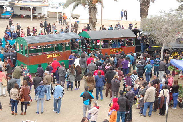
Converted Train Cars Sell Souvenirs in Caldera, Chile
I poked around the old railroad station, which is now a Centro Cultural. Because of the anniversary weekend, there were a lot of food stands selling regional treats like my much-loved churrasca.
Can’t Resist a Churrasca in Caldera, Chile
Old Caldera Railway Sign
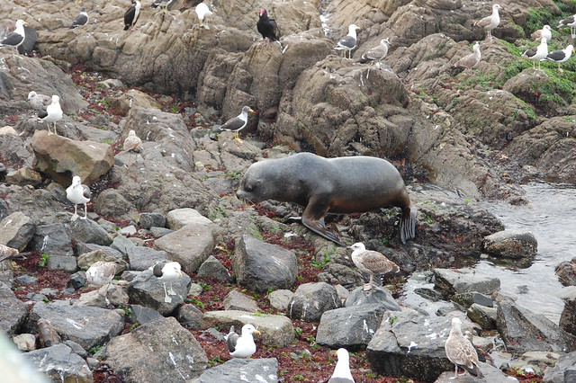
After getting a sense of the town, I wandered over to the fishing docks and watched the pelicans, my favorite seabird. I also watched the sea lions lumbering around on the rocks, going about their business.
Watching the Seabirds Along the Coastal Desert in Caldera, Chile
Sea Lion Doing His Thing in Caldera, Chile
As a vegetarian, I wasn’t tempted by the seafood restaurants or museum on fishing methods, but I did appreciate the murals celebrating traditional fisherman, who also form part of my own family tree, many generations back.
Mural of a Traditional Fisherman, Caldera, Chile
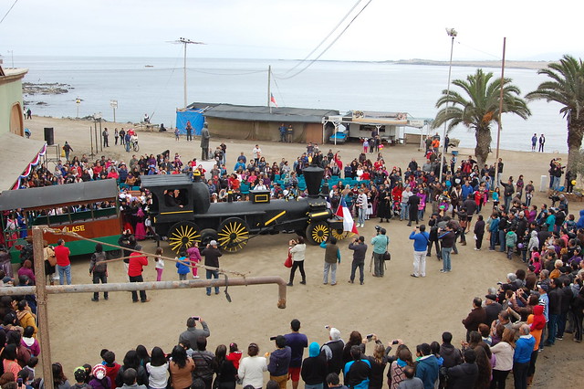
The next morning, the hostal lent me a bike and I headed back into town to watch the main ceremony recreating the first departure of Chile’s first railroad.
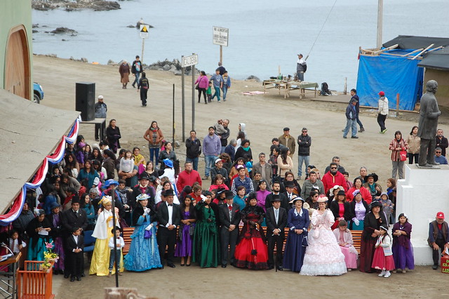
Caldera Residents Dressed in Period Costumes
I appreciated that so many of Caldera’s residents went all out in wearing traditional clothing from the 1800’s. It was nice to see a celebration that was not religious, but rather historical, in nature. After welcoming trekkers who hiked overnight to arrive in Caldera, it was time to cut the ribbon and board the train.
Time to Get on the Train in Caldera, Chile
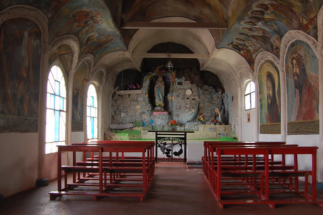
From the center of town, I biked over to the other major destination in Caldera, the Gruta del Padre Negro, a small church sanctuary honoring a priest from Colombia who is known for granting miracles.
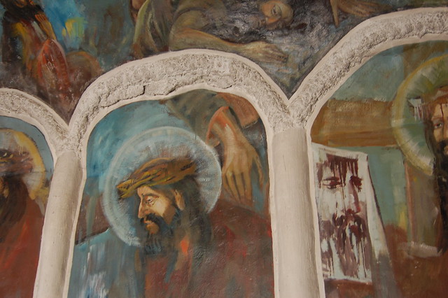
Gruta del Padre Negro, Caldera, Chile
The small building has colorful murals painted all over its interior and the inviting plaza is also a good place to break for a snack.
Murals in the Gruta del Padre Negro, Caldera, Chile
Lighting Candles for Miracles in the Gruta del Padre Negro, Caldera, Chile
I continued along my way the 6km bike path to Bahía Inglesa, a popular tourist destination due to its white sand beaches and jewel-toned waters.
White Sand Beaches and Jewel-Toned Waters in Bahía Inglesa, Caldera, Chile
Bahía Inglesa, Caldera, Chile
Bahía Inglesa is even smaller than Caldera, consisting mainly of beachfront restaurants and cabañas for rent during the tourist season. Although I had planned to spend a leisurely afternoon reading on the beach, the winter winds coming off the water were quite chilly so I decided to head back to Caldera.
Selfie with a Photobomb by a Street Dog, Bahía Inglesa, Caldera, Chile
On the way, I stopped at a viewpoint overlooking Bahía Inglesa, where I took in the surrounding landscape. It surprises me how similar coastal Chile is to coastal Peru, considering the distance, with barren deserts inland and lovely beaches and bays on the water.
Looking Over Bahía Inglesa, Caldera, Chile
Empty Desert Landscape Near Bahiá Inglesa, Caldera, Chile
After returning to Caldera, I took another spin around the town. One thing I thought I would love about Caldera is that it hosts a moai from Easter Island.
Moai from Easter Island in Caldera, Chile
Easter Island is located at about the same latitude as Caldera, so the moai was donated to mark this relationship.
Moai from Easter Island, Looking Out to the Sea in Caldera, Chile
Unfortunately, as with many moai on mainland Chile, this moai has been treated poorly by visitors and is sadly covered with disgusting graffiti.
Much-Abused But Still Dignified Moai in Caldera, Chile
As the sun went down, I headed back to my hostal to wait out the remaining hours until my bus to Iquique, where I would spend the remainder of my winter vacation, enjoying the warmer temperatures of the north!
Recommendations for Caldera, Chile:
Caldera would be a perfect weekend trip and seemed to be a big destination for vacationing couples and families. If I had been in the mood to relax on a retreat, I would have enjoyed staying for longer, but I was antsy to move on to the big city.
I stayed at Hostal El Faro, which is owned by an extremely sweet woman named Mariela. You can book the hostel through AirBnB or on her website. Mariela is incredibly helpful and will pick you up from the bus terminal if you arrange in advance, give you a brief tour of the town to get you situated, and provide suggestions for your visit. She also went out of her way and drove me to the bus station at midnight, and her son lent me a bike for my trip to Bahía Inglesa. I highly recommend staying here as long as you don’t mind being a little ways out of the downtown area. I like walking and it was certainly walkable, but I do suggest using Google Maps to find your way!
The Gruta del Padre Negro is located on the outskirts of town and is worth a stop to see some of the religious heritage of the town.
As mentioned, I happened to visit when the town was celebrating the anniversary of the first railroad in Chile. I appreciated the period costumes and celebrations for the anniversary of the railroad, and if you’re interested in seeing it for yourself, plan a visit in July. More info here on the festivities in 2015.
Bahia Inglesa is an easy 6km trip on paved bike paths from Caldera, as long as you have a good bike. There are bike rental shops in town, or your hostal may be able to lend you one.
There is an artisanal ice cream shop in town, popular among tourists, called Helados Gutierrez.
Pullman and Turbus stop at the tiny bus terminal in town, but you want to make sure you book your ticket in advance and store your luggage at your hostal as the offices are not open at all hours.
Other sights to see in town are the Centro Cultural Ferrocarril, the fishing dock lined with seafood restaurants, the Museo Tortoni. There is more information here in this Wikipedia article (in Spanish).
When I decided to visit Santiago in 2013, I came with few expectations except that I wanted to get a feel for the city and think about moving to Chile (which I eventually did!). My friend Francisca took charge of my initial explorations and brought me to many of the most interesting neighborhoods of Santiago, including Bellavista, where we visited Pablo Neruda’s home, La Chascona, on a rainy day in August. When we headed to Valparaíso, we obviously had to visit the beloved Chilean poet’s other home, La Sebastiana, perched on the hill of Cerro Alegre.
Pablo Neruda’s House in Isla Negra, Chile
After taking in the quirky style preserved in these houses-turned-museums, I knew I had to visit Isla Negra, Pablo Neruda’s biggest and most beautiful home, located a couple of house south of Valparaíso on the Pacific coast. This was one of the top items on my Chile bucket list, so when Sara came to visit, I took advantage of our coastal adventures to get to Isla Negra.
Neruda’s House in Isla Negra, Chile
Despite its name, Isla Negra is not actually an island. If you know anything about Neruda, you know that he was fascinated with all things nautical, so he built his home in the shape of a boat, with views looking directly out to the ocean. Standing in his bedroom and taking in the views of the crashing waves from his bed was incredibly moving for me.
Best Bedroom Windows Ever, Isla Negra, Chile
The Fundacion Pablo Neruda does not permit photography inside any of the poet’s home, so you will have to head there yourself to get a sense of the extensive collections housed within its walls. It is totally worth it just for the views, inspirational in their own right.
I wouldn’t mind sitting at Neruda’s desk and spending a few hours a day writing, looking out towards the ocean every times I needed a break. Nor would I mind sitting in the breakfast nook and having a cup of tea, or sharing several bottles of wine with a large assortment of friends over his massive dining room table.
Neruda’s Collection, Isla Negra, Chile
For craft fans like me, the museum also celebrates the embroidery of a women’s embroidery collective that Neruda supported. Their creations are intricate and gorgeous, if beyond my budget, and if you’re interested in their techniques, the museum sells starter embroidery kits.
Even though Isla Negra is a popular tourist destination, it seems most people arrive by car, and I found it a bit challenging to find information on how to get there. You can get there from either Valparaíso or Santiago, and it is worth the journey for a pleasant day trip. I would suggest going earlier in the day to enjoy some seaside empanadas or spend some time on the beach. Below, I’ve listed my other suggestions as well as tips on how to get to Isla Negra on public transportation.
If you weren’t such a fan of the houses in Bellavista or Valpo (like me), Isla Negra is a completely different experience. If you can only visit one of Neruda’s houses, make it this one.
Sunset En Route to Santiago from Isla Negra, Chile
Recommendations for Isla Negra, Chile:
Buses leaves for Isla Negra from the Valparaíso bus terminal, located by the Congreso. I did not see a posted schedule but they seemed to leave every hour. Make sure you tell the driver you want to get off in Isla Negra. The bus cost $4000CLP on my visit during busy winter vacation.
If you are staying in Viña del Mar, as we were, you will have to take a local bus to Valparaíso and then leave from there. There no buses from Viña to Isla Negra.
If you would like to head to Isla Negra from Santiago, this is totally possible! Pullman has a bus route through the Casablanca Valley that passes right through Isla Negra. The buses leave from the Pajaritos and Alameda bus terminals, both located on the Metro Linea 1 (red line). If you’re taking the metro, you might as well just go directly to Pajaritos as it is a brand new, beautiful terminal and the buses will go there after passengers board at Terminal Alameda. (It’s also a little safer, in my opinion.) Buses leave every 15-30 minutes and you’ll need to buy tickets before boarding.
We caught a direct bus back to Santiago from Isla Negra, right on the main street. There is a Pullman office in the center of town which offers luggage storage, which is a great option for those travelers like us who were just passing through but still had our luggage.
You can see more about the Pullman Bus routes here, but remember that you won’t be able to buy tickets online because these are regional buses rather than long-distance buses.
The Isla Negra museum has luggage storage in the form of free lockers, and we were able to get our medium sized backpack and suitcase into them.
Try to visit the museum on an off day. The number of visitors allowed into the house at a certain time is restricted and on weekends, holidays, or vacation weeks, this can mean an hour or two wait and a very crowded tour. Even though the tour is with an audioguide, you still move through the house as a group and it can feel a little clausterphobic.
Take some time to walk down to the beach and browse the artisan wares being sold along the beach path.
Entry to the museum costs $5000. There is an on-site cafe and gift shop, and if you are lucky, there will be a table selling the intricate embroidery from the artisan collective. Even though it is pricey, it is well worth a look to admire the detailed work.
Back in 2013, when I was visiting Chile in order to get a sense of whether I might like to move here, my friend Francisca took me to all the main tourist destinations around Santiago, including a whirlwind tour of nearby Viña del Mar and Valparaíso. On my first visit, we stopped at the Museo Fonck so I could see the Easter Island exhibit, then followed that up with some empanadas and a walk on the beach before continuing onward to Valpo.
Scenes from Viña del Mar, Chile (the quote reads “Don’t let the bad defeat you; use good to defeat the bad”)
That quick visit left a good impression on me, so I put a return visit to Viña on my Chile bucket list. When my friend Sara decided to make the journey south to Chile during my winter vacation, I saw a good opportunity to return. Since she arrived in the middle of winter (and being from Boston, neither of us are desperate to see more snow!), we decided to stay on the coast. Sara headed to Valparaíso on a solo adventure and covered so much territory in her explorations that it made more sense to visit Viña del Mar together.
Views of Viña del Mar, Chile
Viña del Mar is an attractive coastal city with plenty of beach to wander at any point of the year. The climate is mild even in winter, and even on cloudy days the sun manages to peek out, as you can see in my photos. We caught a Viña bound bus from the Pajaritos terminal and enjoyed the comfortable ride to our next destination. After checking in to our AirBnB close to the beach, we headed out to wander along the coastline.
Walking on the Beach in Viña del Mar, Chile
Once we reached the beach, I realized that I already knew this stretch of sand, captured in one of my favorite photos of myself. It was a little surreal to recover the same ground as two years before, with a completely different perspective on Chile.
Casino in Viña del Mar, Chile
Thankfully, Sara is a relaxed traveler and was equally content to wander along the coast and get a sense of Valpo’s sister city. While the botanical gardens were too far away for a short off-season visit, I wanted to make sure we took in the Castillo Wulff (Wulff Castle) and Reloj de Flores (Flower Clock), two distinctive characteristics of Vina del Mar.
Posing in Front of Castillo Wulff, Viña del Mar, Chile
Castillo Wulff, Viña del Mar, Chile
Castillo Wulff was built by a businessman of German heritage back in 1906, and is still a popular spot with tourists due to its great vantage point and distinctive architecture.
Posing with Sara at the Viewpoint Above Castillo Wulff, Viña del Mar, Chile
Inside the castle, there is small gallery with temporary exhibits, run by the municipality of Viña del Mar. On my visit, the gallery displayed intricate embroidery by local artists, which was perfect for me as a huge fan of textile art.
Embroidery in the Exhibit at Castillo Wulff, Viña del Mar, Chile
Combined with the amazing folk art exhibit in the Centro Cultural La Moneda in Santiago and the artisan collective at Isla Negra, I am pretty inspired to keep learning more techniques in embroidery.
Views of Viña del Mar, Chile
After visiting the castle, we continued along the coast, taking in the views over the ocean right from the sidewalk.
Seabirds in the Late Afternoon Sun, Viña del Mar, Chile
The seabirds circled above, leading me to catch some pretty nice shots of the ocean in the late afternoon sun.
Reloj de Flores (Flower Clock), Viña del Mar, Chile
After crossing some major streets, we reached the Reloj de Flores, a touristy but attractively landscaped clock located by the one of the entrances to the commerical district. I was particularly intrigued by the plants in the little plaza, which appeared to be kale or cabbage, quite eye-catching in their own right (maybe even cooler than the clock, if you ask me!).
Pretty Landscaping in Viña del Mar, Chile
Mission accomplished, we headed back along the coast in search of an affordable and hopefully delicious dinner. The late afternoon mix of sun and clouds led to some pretty beautiful skies.
Enjoying the Views in Viña del Mar, Chile
We ended up getting pizza at Diego Pizza, a restaurant I was drawn to due to its clean design. Happily, they had the best pizza I’ve had to date in Chile, made even more flavorful by its roasted garlic and onion. We added in a big fresh salad for balance.
Our Delicious Meal at Diego Pizza, Viña del Mar
After eating, we hurried outside to catch the tail end of an amazing sunset. That is one of the best things about staying blocks from the beach; the sunsets are all the more accessible.
Sunset in Viña del Mar, Chile
The next morning, we enjoyed a delicious American-style breakfast at our AirBnB before beginning our journey to Isla Negra. While I would probably want more time in Viña during the warm, sunny summer, this was a perfect overnight trip during my winter break and I feel like I got to know the city a little better this time around!
Viña del Mar, Chile
Recommendations for Vina del Mar:
Direct buses to Viña del Mar run from Terminal Alameda and Terminal Pajaritos in Santiago. If you are heading to the bus terminal on the metro, you may as well head directly to Pajaritos as the buses stop in both locations. You buy your tickets from the kiosks inside the newly remodeled terminals. On a holiday during winter vacation, a one way ticket cost $4000CLP.
We ended up taking a taxi to our AirBnB, but be aware that taxis are very expensive in Viña and the city is pretty walkable from the bus terminal.
Local buses cost $400 per ride, and I found both strangers on the street and bus employees to be quite helpful with helping us get to the bus terminal and to Valparaiso.
We stayed at the Speakeasy Guest House, which we booked through AirBnb. The location is excellent, near the shopping mall, the beach, and a number of restaurants. The owner, a Chilean-American, provides an excellent large American-style breakfast in the morning. He’s a trained chef so it’s worth it just to enjoy the breakfast!
I suggest spending some time around the colonial buildings downtown, including Museo Fonck, enjoying empanadas at an open air restaurant, checking out Castillo Wulff, and the Reloj de Flores. Viña is also known for its botantical gardens.